Cavaglià geodata
Cavaglià (Piedmont) is a seat of a third-order administrative division; located in Italy in Europe/Rome (GMT+2) time zone. With population of 2,741 people, there are 3275 cities with bigger population in this country. Compared to other cities in Italy, 70.4% of cities are located further ↓South; 92.4% of cities are located further →East and 57.1% of cities have lower elevation than Cavaglià. Note1


Cavaglià GPS coordinates[2]
45° 24' 21.672" North, 8° 5' 29.868" East
| Map corner | latitude | longitude |
|---|---|---|
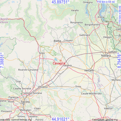
| Upper-left | 45.89751°, | 7.38851° |
| Center: | 45.40602°, | 8.09163° |
| Lower-right: | 44.91021°, | 8.79476° |
| Map W x H: | 109.8×109.8 km | = 68.2×68.2mi |
| max Lat: | 47.04031° ⇑29.6% North |
| Cavaglià: | 45.40602° |
| min Lat: | ⇓70.4% South 35.50142° |
| min Long | Cavaglià | max Long |
| 6.69888° | 8.09163° | 18.48682° |
| W 7.6%⇐ | ⇒92.4% E |
Elevation
Elevation of Cavaglià is 279 m = 915 ft, and this is 27.7 m = 91 ft below average elevation for this country.
| Max E: |
2085 m = 6841 ft | 42.9% |
| Avg. | 306.7 m = 1006 ft | |
| Cavaglià | 279 m = 915 ft | |
Min E: |
-4 m = -13 ft | 57.1% |
See also: Italy elevation on elevation.city.
Geographical zone
Cavaglià is located in North temperate zone (between Tropic of Cancer and the Arctic Circle). Distance of this North polar circle is 2352.5 km =1461.8 mi to North.| Distance of | km | miles | from Cavaglià |
|---|---|---|---|
| North Pole | 4958.4 | 3081 | to North |
| Arctic Circle | 2352.5 | 1461.8 | to North |
| Tropic Cancer | 2442.8 | 1517.9 | to South |
| Equator | 5048.7 | 3137.1 | to South |


Nearby cities:
15 places around Cavaglià: (largest is in red/bold)
• Alice Castello
4.4 km =2.7 mi,  199°
199°
• Azeglio
8 km =5 mi,  283°
283°
• Borgo d'Ale
7 km =4.3 mi,  206°
206°
• Carisio
8.4 km =5.2 mi,  86°
86°
• Cerrione
7.3 km =4.5 mi,  345°
345°
• Cossano Canavese
8.1 km =5 mi,  255°
255°
• Dorzano
2.3 km =1.4 mi,  13°
13°
• Piverone
7.9 km =4.9 mi,  303°
303°
• Roppolo
2.4 km =1.5 mi,  313°
313°
• Salussola
4.8 km =3 mi,  18°
18°
• Santhià
7.4 km =4.6 mi,  124°
124°
• Settimo Rottaro
7.7 km =4.8 mi,  271°
271°
• Vigellio
6.4 km =4 mi, 16°
• Viverone
4.1 km =2.5 mi, 305°
• Zimone
6.4 km =4 mi,  318°
318°
Sources, notices
• [Note1] Compared only with cities in Italy existing in our database
• [Src1] Map data: © OpenStreetMap contributors (CC-BY-SA)
• [Src2] Other city data from geonames.org with taken over terms of usage.
• [Src3] Geographical zone / Annual Mean Temperature by Robert A. Rohde @ Wikipedia
