Borgomale geodata
Borgomale (Piedmont) is a seat of a third-order administrative division; located in Italy in Europe/Rome (GMT+2) time zone. With population of 20 people, there are 11679 cities with bigger population in this country. Compared to other cities in Italy, 52.8% of cities are located further ↓South; 91.9% of cities are located further →East and 75.2% of cities have lower elevation than Borgomale. Note1


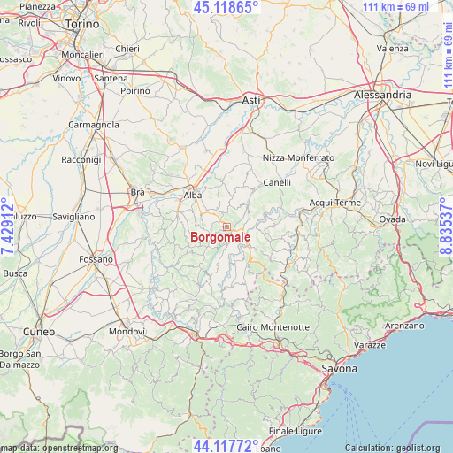
Borgomale GPS coordinates[2]
44° 37' 13.224" North, 8° 7' 56.064" East
| Map corner | latitude | longitude |
|---|---|---|
| Upper-left | 45.11865°, | 7.42912° |
| Center: | 44.62034°, | 8.13224° |
| Lower-right: | 44.11772°, | 8.83537° |
| Map W x H: | 111.3×111.3 km | = 69.2×69.2mi |
| max Lat: | 47.04031° ⇑47.2% North |
| Borgomale: | 44.62034° |
| min Lat: | ⇓52.8% South 35.50142° |
| min Long | Borgomale | max Long |
| 6.69888° | 8.13224° | 18.48682° |
| W 8.1%⇐ | ⇒91.9% E |
Elevation
Elevation of Borgomale is 454 m = 1490 ft, and this is 147.3 m = 483 ft above average elevation for this country.
| Max E: |
2085 m = 6841 ft | 24.8% |
| Borgomale | 454 m 1490 ft | |
| Avg. | 306.7 m = 1006 ft | |
Min E: |
-4 m = -13 ft | 75.2% |
See also: Italy elevation on elevation.city.
Geographical zone
Borgomale is located in North temperate zone (between Tropic of Cancer and the Arctic Circle). Distance of this Northern Tropic circle is 2355.4 km =1463.6 mi to South.| Distance of | km | miles | from Borgomale |
|---|---|---|---|
| North Pole | 5045.7 | 3135.3 | to North |
| Arctic Circle | 2439.9 | 1516.1 | to North |
| Tropic Cancer | 2355.4 | 1463.6 | to South |
| Equator | 4961.3 | 3082.8 | to South |


Nearby cities:
15 places around Borgomale: (largest is in red/bold)
• Albaretto della Torre
6 km =3.7 mi,  243°
243°
• Arguello
4.5 km =2.8 mi,  202°
202°
• Benevello
2.4 km =1.5 mi,  296°
296°
• Bosia
2.3 km =1.4 mi,  149°
149°
• Castino
4 km =2.5 mi,  94°
94°
• Cerreto Langhe
5.7 km =3.5 mi,  208°
208°
• Cortemilia
6.6 km =4.1 mi,  132°
132°
• Cravanzana
5.1 km =3.2 mi,  184°
184°
• Lequio Berria
3.1 km =1.9 mi, 239°
• Montelupo Albese
6.7 km =4.2 mi,  271°
271°
• Perletto
6.8 km =4.2 mi,  110°
110°
• Rocchetta Belbo
3.8 km =2.4 mi,  62°
62°
• Rodello
6 km =3.7 mi,  278°
278°
• Torre Bormida
6.6 km =4.1 mi,  164°
164°
• Trezzo Tinella
6.6 km =4.1 mi,  342°
342°
Sources, notices
• [Note1] Compared only with cities in Italy existing in our database
• [Src1] Map data: © OpenStreetMap contributors (CC-BY-SA)
• [Src2] Other city data from geonames.org with taken over terms of usage.
• [Src3] Geographical zone / Annual Mean Temperature by Robert A. Rohde @ Wikipedia
