Blera geodata
Blera (Latium) is a seat of a third-order administrative division; located in Italy in Europe/Rome (GMT+2) time zone. With population of 2,549 people, there are 3464 cities with bigger population in this country. Compared to other cities in Italy, 68% of cities are located further ↑North; 56.3% of cities are located further ←West and 58.2% of cities have lower elevation than Blera. Note1


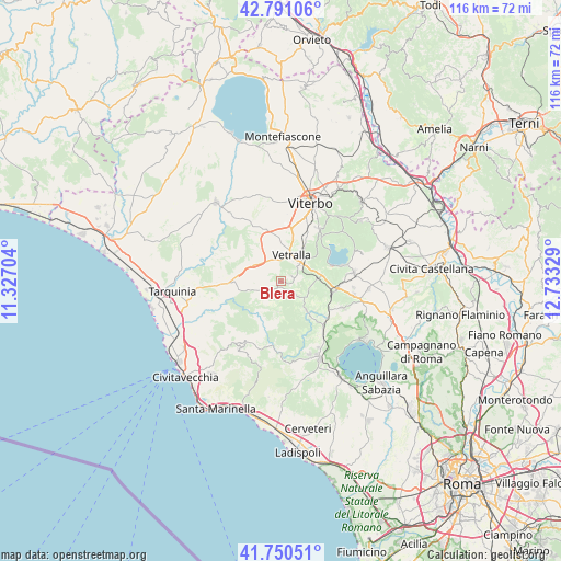
Blera GPS coordinates[2]
42° 16' 22.548" North, 12° 1' 48.576" East
| Map corner | latitude | longitude |
|---|---|---|
| Upper-left | 42.79106°, | 11.32704° |
| Center: | 42.27293°, | 12.03016° |
| Lower-right: | 41.75051°, | 12.73329° |
| Map W x H: | 115.7×115.7 km | = 71.9×71.9mi |
| max Lat: | 47.04031° ⇑68% North |
| Blera: | 42.27293° |
| min Lat: | ⇓32% South 35.50142° |
| min Long | Blera | max Long |
| 6.69888° | 12.03016° | 18.48682° |
| W 56.3%⇐ | ⇒43.7% E |
Elevation
Elevation of Blera is 287 m = 942 ft, and this is 19.7 m = 65 ft below average elevation for this country.
| Max E: |
2085 m = 6841 ft | 41.8% |
| Avg. | 306.7 m = 1006 ft | |
| Blera | 287 m = 942 ft | |
Min E: |
-4 m = -13 ft | 58.2% |
See also: Italy elevation on elevation.city.
Geographical zone
Blera is located in North temperate zone (between Tropic of Cancer and the Arctic Circle). Distance of this Northern Tropic circle is 2094.4 km =1301.4 mi to South.| Distance of | km | miles | from Blera |
|---|---|---|---|
| North Pole | 5306.8 | 3297.5 | to North |
| Arctic Circle | 2700.9 | 1678.3 | to North |
| Tropic Cancer | 2094.4 | 1301.4 | to South |
| Equator | 4700.3 | 2920.6 | to South |


Nearby cities:
15 places around Blera: (largest is in red/bold)
• Barbarano Romano
4.1 km =2.5 mi,  130°
130°
• Bassano Romano
14.1 km =8.8 mi,  113°
113°
• Canale Monterano
16.4 km =10.2 mi,  158°
158°
• Capranica
11.8 km =7.3 mi,  97°
97°
• Colle Diana
15.2 km =9.4 mi, 95°
• Monte Romano
11 km =6.8 mi,  266°
266°
• Montevirginio
15.9 km =9.9 mi,  150°
150°
• Oriolo Romano
15.2 km =9.4 mi,  143°
143°
• Ronciglione
15.3 km =9.5 mi,  83°
83°
• San Martino al Cimino
13.3 km =8.3 mi,  35°
35°
• Sutri
15.7 km =9.8 mi, 101°
• Tolfa
15.9 km =9.9 mi,  210°
210°
• Vejano
8 km =5 mi, 138°
• Vetralla
6.1 km =3.8 mi, 35°
• Villa San Giovanni in Tuscia
2 km =1.2 mi,  71°
71°
Sources, notices
• [Note1] Compared only with cities in Italy existing in our database
• [Src1] Map data: © OpenStreetMap contributors (CC-BY-SA)
• [Src2] Other city data from geonames.org with taken over terms of usage.
• [Src3] Geographical zone / Annual Mean Temperature by Robert A. Rohde @ Wikipedia
