Biella geodata
Biella (Piedmont) is a seat of a second-order administrative division; located in Italy in Europe/Rome (GMT+2) time zone. With population of 43,030 people, there are 162 cities with bigger population in this country. Compared to other cities in Italy, 75.6% of cities are located further ↓South; 92.9% of cities are located further →East and 72.5% of cities have lower elevation than Biella. Note1


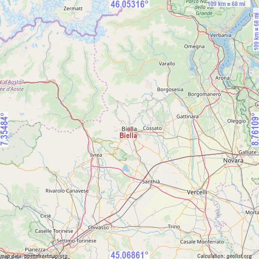
Biella GPS coordinates[2]
45° 33' 46.944" North, 8° 3' 28.656" East
| Map corner | latitude | longitude |
|---|---|---|
| Upper-left | 46.05316°, | 7.35484° |
| Center: | 45.56304°, | 8.05796° |
| Lower-right: | 45.06861°, | 8.76109° |
| Map W x H: | 109.5×109.5 km | = 68×68mi |
| max Lat: | 47.04031° ⇑24.4% North |
| Biella: | 45.56304° |
| min Lat: | ⇓75.6% South 35.50142° |
| min Long | Biella | max Long |
| 6.69888° | 8.05796° | 18.48682° |
| W 7.1%⇐ | ⇒92.9% E |
Elevation
Elevation of Biella is 420 m = 1378 ft, and this is 113.3 m = 372 ft above average elevation for this country.
| Max E: |
2085 m = 6841 ft | 27.5% |
| Biella | 420 m 1378 ft | |
| Avg. | 306.7 m = 1006 ft | |
Min E: |
-4 m = -13 ft | 72.5% |
See also: Biella elevation on elevation.city.
Geographical zone
Biella is located in North temperate zone (between Tropic of Cancer and the Arctic Circle). Distance of this North polar circle is 2335 km =1450.9 mi to North.| Distance of | km | miles | from Biella |
|---|---|---|---|
| North Pole | 4940.9 | 3070.1 | to North |
| Arctic Circle | 2335 | 1450.9 | to North |
| Tropic Cancer | 2460.2 | 1528.7 | to South |
| Equator | 5066.1 | 3147.9 | to South |


Nearby cities:
15 places around Biella: (largest is in red/bold)
• Andorno Cacciorna
5.3 km =3.3 mi,  358°
358°
• Camburzano
4.8 km =3 mi,  243°
243°
• Candelo
4.5 km =2.8 mi,  122°
122°
• Gaglianico
3.3 km =2.1 mi,  151°
151°
• Occhieppo Inferiore
3.2 km =2 mi, 243°
• Occhieppo Superiore
4 km =2.5 mi,  271°
271°
• Pollone
4.5 km =2.8 mi,  294°
294°
• Ponderano
2.7 km =1.7 mi,  183°
183°
• Pralungo
3.3 km =2.1 mi,  334°
334°
• Ronco Biellese
3.1 km =1.9 mi,  56°
56°
• Sandigliano
4.8 km =3 mi,  162°
162°
• Ternengo
5.2 km =3.2 mi, 56°
• Tollegno
3.1 km =1.9 mi,  349°
349°
• Vigliano Biellese
3.7 km =2.3 mi,  89°
89°
• Zumaglia
4.2 km =2.6 mi,  35°
35°
Sources, notices
• [Note1] Compared only with cities in Italy existing in our database
• [Src1] Map data: © OpenStreetMap contributors (CC-BY-SA)
• [Src2] Other city data from geonames.org with taken over terms of usage.
• [Src3] Geographical zone / Annual Mean Temperature by Robert A. Rohde @ Wikipedia
