Anzi geodata
Anzi (Basilicate) is a seat of a third-order administrative division; located in Italy in Europe/Rome (GMT+2) time zone. With population of 1,299 people, there are 5639 cities with bigger population in this country. Compared to other cities in Italy, 84% of cities are located further ↑North; 92.4% of cities are located further ←West and 97% of cities have lower elevation than Anzi. Note1


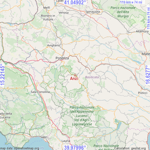
Anzi GPS coordinates[2]
40° 30' 59.832" North, 15° 55' 28.452" East
| Map corner | latitude | longitude |
|---|---|---|
| Upper-left | 41.04902°, | 15.22145° |
| Center: | 40.51662°, | 15.92457° |
| Lower-right: | 39.97996°, | 16.6277° |
| Map W x H: | 118.9×118.9 km | = 73.9×73.9mi |
| max Lat: | 47.04031° ⇑84% North |
| Anzi: | 40.51662° |
| min Lat: | ⇓16% South 35.50142° |
| min Long | Anzi | max Long |
| 6.69888° | 15.92457° | 18.48682° |
| W 92.4%⇐ | ⇒7.6% E |
Elevation
Elevation of Anzi is 998 m = 3274 ft, and this is 691.3 m = 2268 ft above average elevation for this country.
| Max E: |
2085 m = 6841 ft | 3% |
| Anzi | 998 m 3274 ft | |
| Avg. | 306.7 m = 1006 ft | |
Min E: |
-4 m = -13 ft | 97% |
See also: Italy elevation on elevation.city.
Geographical zone
Anzi is located in North temperate zone (between Tropic of Cancer and the Arctic Circle). Distance of this Northern Tropic circle is 1899.1 km =1180 mi to South.| Distance of | km | miles | from Anzi |
|---|---|---|---|
| North Pole | 5502 | 3418.8 | to North |
| Arctic Circle | 2896.1 | 1799.6 | to North |
| Tropic Cancer | 1899.1 | 1180 | to South |
| Equator | 4505 | 2799.3 | to South |


Nearby cities:
15 places around Anzi: (largest is in red/bold)
• Abriola
9.5 km =5.9 mi,  263°
263°
• Albano di Lucania
12.3 km =7.6 mi,  50°
50°
• Brindisi Montagna
10.4 km =6.5 mi,  7°
7°
• Calvello
7.8 km =4.8 mi,  233°
233°
• Campomaggiore
13.6 km =8.5 mi,  66°
66°
• Castelmezzano
10.3 km =6.4 mi,  82°
82°
• Corleto Perticara
17.8 km =11.1 mi,  147°
147°
• Laurenzana
7.5 km =4.7 mi, 148°
• Madonna del Pantano
14.2 km =8.8 mi,  293°
293°
• Marsicovetere
17.7 km =11 mi,  208°
208°
• Pietrapertosa
11.7 km =7.3 mi,  89°
89°
• Pignola
13.6 km =8.5 mi,  298°
298°
• Potenza
17 km =10.6 mi,  324°
324°
• Trivigno
8.9 km =5.5 mi,  37°
37°
• Vaglio Basilicata
16.7 km =10.4 mi,  357°
357°
Sources, notices
• [Note1] Compared only with cities in Italy existing in our database
• [Src1] Map data: © OpenStreetMap contributors (CC-BY-SA)
• [Src2] Other city data from geonames.org with taken over terms of usage.
• [Src3] Geographical zone / Annual Mean Temperature by Robert A. Rohde @ Wikipedia
