Andrate geodata
Andrate (Piedmont) is a seat of a third-order administrative division; located in Italy in Europe/Rome (GMT+2) time zone. With population of 388 people, there are 10328 cities with bigger population in this country. Compared to other cities in Italy, 74.5% of cities are located further ↓South; 94.9% of cities are located further →East and 92.6% of cities have lower elevation than Andrate. Note1


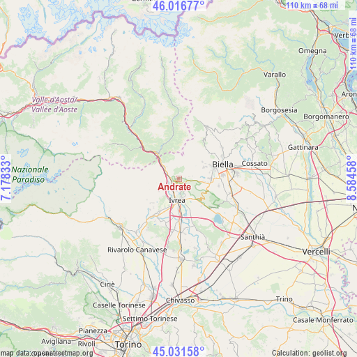
Andrate GPS coordinates[2]
45° 31' 34.788" North, 7° 52' 53.22" East
| Map corner | latitude | longitude |
|---|---|---|
| Upper-left | 46.01677°, | 7.17833° |
| Center: | 45.52633°, | 7.88145° |
| Lower-right: | 45.03158°, | 8.58458° |
| Map W x H: | 109.5×109.5 km | = 68×68mi |
| max Lat: | 47.04031° ⇑25.5% North |
| Andrate: | 45.52633° |
| min Lat: | ⇓74.5% South 35.50142° |
| min Long | Andrate | max Long |
| 6.69888° | 7.88145° | 18.48682° |
| W 5.1%⇐ | ⇒94.9% E |
Elevation
Elevation of Andrate is 788 m = 2585 ft, and this is 481.3 m = 1579 ft above average elevation for this country.
| Max E: |
2085 m = 6841 ft | 7.4% |
| Andrate | 788 m 2585 ft | |
| Avg. | 306.7 m = 1006 ft | |
Min E: |
-4 m = -13 ft | 92.6% |
See also: Italy elevation on elevation.city.
Geographical zone
Andrate is located in North temperate zone (between Tropic of Cancer and the Arctic Circle). Distance of this North polar circle is 2339.1 km =1453.4 mi to North.| Distance of | km | miles | from Andrate |
|---|---|---|---|
| North Pole | 4945 | 3072.7 | to North |
| Arctic Circle | 2339.1 | 1453.4 | to North |
| Tropic Cancer | 2456.1 | 1526.1 | to South |
| Equator | 5062.1 | 3145.4 | to South |


Nearby cities:
15 places around Andrate: (largest is in red/bold)
• Borgofranco d'Ivrea
2.1 km =1.3 mi,  238°
238°
• Burolo
6.5 km =4 mi,  140°
140°
• Cascinette d'Ivrea
5.5 km =3.4 mi,  159°
159°
• Chiaverano
3.5 km =2.2 mi,  151°
151°
• Donato
2.2 km =1.4 mi,  90°
90°
• Ivrea
6.6 km =4.1 mi,  183°
183°
• Montalto Dora
4.3 km =2.7 mi,  200°
200°
• Netro
5.3 km =3.3 mi,  73°
73°
• Nomaglio
2 km =1.2 mi,  303°
303°
• Quassolo
3.8 km =2.4 mi,  264°
264°
• Quincinetto
6.9 km =4.3 mi, 304°
• Sala Biellese
6.3 km =3.9 mi,  108°
108°
• Settimo Vittone
4.5 km =2.8 mi, 304°
• Tavagnasco
5 km =3.1 mi,  293°
293°
• Torrazzo
6.5 km =4 mi,  118°
118°
Sources, notices
• [Note1] Compared only with cities in Italy existing in our database
• [Src1] Map data: © OpenStreetMap contributors (CC-BY-SA)
• [Src2] Other city data from geonames.org with taken over terms of usage.
• [Src3] Geographical zone / Annual Mean Temperature by Robert A. Rohde @ Wikipedia
