Andezeno geodata
Andezeno (Piedmont) is a seat of a third-order administrative division; located in Italy in Europe/Rome (GMT+2) time zone. With population of 1,744 people, there are 4581 cities with bigger population in this country. Compared to other cities in Italy, 60.8% of cities are located further ↓South; 95% of cities are located further →East and 57% of cities have lower elevation than Andezeno. Note1


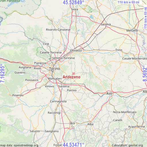
Andezeno GPS coordinates[2]
45° 2' 1.536" North, 7° 51' 57.852" East
| Map corner | latitude | longitude |
|---|---|---|
| Upper-left | 45.52849°, | 7.16295° |
| Center: | 45.03376°, | 7.86607° |
| Lower-right: | 44.53471°, | 8.5692° |
| Map W x H: | 110.5×110.5 km | = 68.7×68.7mi |
| max Lat: | 47.04031° ⇑39.2% North |
| Andezeno: | 45.03376° |
| min Lat: | ⇓60.8% South 35.50142° |
| min Long | Andezeno | max Long |
| 6.69888° | 7.86607° | 18.48682° |
| W 5%⇐ | ⇒95% E |
Elevation
Elevation of Andezeno is 278 m = 912 ft, and this is 28.7 m = 94 ft below average elevation for this country.
| Max E: |
2085 m = 6841 ft | 43% |
| Avg. | 306.7 m = 1006 ft | |
| Andezeno | 278 m = 912 ft | |
Min E: |
-4 m = -13 ft | 57% |
See also: Italy elevation on elevation.city.
Geographical zone
Andezeno is located in North temperate zone (between Tropic of Cancer and the Arctic Circle). Distance of this North polar circle is 2393.9 km =1487.5 mi to North.| Distance of | km | miles | from Andezeno |
|---|---|---|---|
| North Pole | 4999.8 | 3106.7 | to North |
| Arctic Circle | 2393.9 | 1487.5 | to North |
| Tropic Cancer | 2401.4 | 1492.2 | to South |
| Equator | 5007.3 | 3111.4 | to South |


Nearby cities:
15 places around Andezeno: (largest is in red/bold)
• Arignano
2.9 km =1.8 mi,  76°
76°
• Baldissero Torinese
5.7 km =3.5 mi,  312°
312°
• Buttigliera d'Asti
6.8 km =4.2 mi,  101°
101°
• Castelnuovo Don Bosco
7.7 km =4.8 mi, 84°
• Chieri
4.4 km =2.7 mi,  233°
233°
• Marentino
2.4 km =1.5 mi,  19°
19°
• Mombello di Torino
4.5 km =2.8 mi,  72°
72°
• Moncucco Torinese
6.4 km =4 mi,  54°
54°
• Montaldo Torinese
3.7 km =2.3 mi,  340°
340°
• Moriondo Torinese
5.9 km =3.7 mi, 84°
• Pavarolo
4.2 km =2.6 mi,  330°
330°
• Pessione
7.9 km =4.9 mi,  194°
194°
• Pino Torinese
7 km =4.3 mi,  275°
275°
• Riva Presso Chieri
5.6 km =3.5 mi,  174°
174°
• Sciolze
6.8 km =4.2 mi,  8°
8°
Sources, notices
• [Note1] Compared only with cities in Italy existing in our database
• [Src1] Map data: © OpenStreetMap contributors (CC-BY-SA)
• [Src2] Other city data from geonames.org with taken over terms of usage.
• [Src3] Geographical zone / Annual Mean Temperature by Robert A. Rohde @ Wikipedia
