Camandona geodata
Camandona (Piedmont) is a seat of a third-order administrative division; located in Italy in Europe/Rome (GMT+2) time zone. With population of 401 people, there are 10277 cities with bigger population in this country. Compared to other cities in Italy, 78.8% of cities are located further ↓South; 92.3% of cities are located further →East and 93% of cities have lower elevation than Camandona. Note1


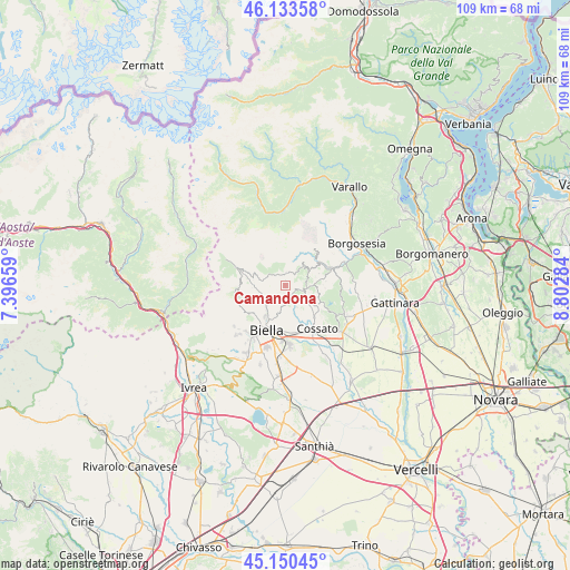
Camandona GPS coordinates[2]
45° 38' 39.012" North, 8° 5' 58.992" East
| Map corner | latitude | longitude |
|---|---|---|
| Upper-left | 46.13358°, | 7.39659° |
| Center: | 45.64417°, | 8.09972° |
| Lower-right: | 45.15045°, | 8.80284° |
| Map W x H: | 109.3×109.3 km | = 67.9×67.9mi |
| max Lat: | 47.04031° ⇑21.2% North |
| Camandona: | 45.64417° |
| min Lat: | ⇓78.8% South 35.50142° |
| min Long | Camandona | max Long |
| 6.69888° | 8.09972° | 18.48682° |
| W 7.7%⇐ | ⇒92.3% E |
Elevation
Elevation of Camandona is 802 m = 2631 ft, and this is 495.3 m = 1625 ft above average elevation for this country.
| Max E: |
2085 m = 6841 ft | 7% |
| Camandona | 802 m 2631 ft | |
| Avg. | 306.7 m = 1006 ft | |
Min E: |
-4 m = -13 ft | 93% |
See also: Italy elevation on elevation.city.
Geographical zone
Camandona is located in North temperate zone (between Tropic of Cancer and the Arctic Circle). Distance of this North polar circle is 2326 km =1445.3 mi to North.| Distance of | km | miles | from Camandona |
|---|---|---|---|
| North Pole | 4931.9 | 3064.5 | to North |
| Arctic Circle | 2326 | 1445.3 | to North |
| Tropic Cancer | 2469.2 | 1534.3 | to South |
| Equator | 5075.2 | 3153.6 | to South |


Nearby cities:
15 places around Camandona: (largest is in red/bold)
• Andorno Cacciorna
5.1 km =3.2 mi,  222°
222°
• Bioglio-Portula-Andrè
4.3 km =2.7 mi,  138°
138°
• Borgo
1.3 km =0.8 mi,  116°
116°
• Callabiana - Chiesa
1.4 km =0.9 mi,  187°
187°
• Crocemosso
4.2 km =2.6 mi,  90°
90°
• Giardino-Botto
4.9 km =3 mi,  76°
76°
• Livera
3.6 km =2.2 mi,  172°
172°
• Mosso
3 km =1.9 mi, 77°
• Mosso Santa Maria
2.9 km =1.8 mi, 78°
• Pettinengo
3.5 km =2.2 mi, 174°
• Sagliano Micca
4.8 km =3 mi,  244°
244°
• Selve Marcone
2.9 km =1.8 mi,  199°
199°
• Tavigliano
4.5 km =2.8 mi, 236°
• Valle Mosso
4 km =2.5 mi,  111°
111°
• Veglio
1.2 km =0.7 mi, 109°
Sources, notices
• [Note1] Compared only with cities in Italy existing in our database
• [Src1] Map data: © OpenStreetMap contributors (CC-BY-SA)
• [Src2] Other city data from geonames.org with taken over terms of usage.
• [Src3] Geographical zone / Annual Mean Temperature by Robert A. Rohde @ Wikipedia
