Antignano geodata
Antignano (Piedmont) is a seat of a third-order administrative division; located in Italy in Europe/Rome (GMT+2) time zone. With population of 421 people, there are 10196 cities with bigger population in this country. Compared to other cities in Italy, 57% of cities are located further ↓South; 91.8% of cities are located further →East and 53.6% of cities have lower elevation than Antignano. Note1


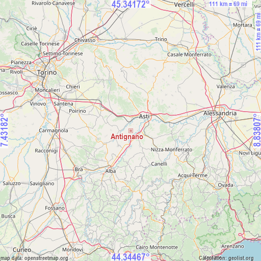
Antignano GPS coordinates[2]
44° 50' 43.26" North, 8° 8' 5.784" East
| Map corner | latitude | longitude |
|---|---|---|
| Upper-left | 45.34172°, | 7.43182° |
| Center: | 44.84535°, | 8.13494° |
| Lower-right: | 44.34467°, | 8.83807° |
| Map W x H: | 110.9×110.9 km | = 68.9×68.9mi |
| max Lat: | 47.04031° ⇑43% North |
| Antignano: | 44.84535° |
| min Lat: | ⇓57% South 35.50142° |
| min Long | Antignano | max Long |
| 6.69888° | 8.13494° | 18.48682° |
| W 8.2%⇐ | ⇒91.8% E |
Elevation
Elevation of Antignano is 257 m = 843 ft, and this is 49.7 m = 163 ft below average elevation for this country.
| Max E: |
2085 m = 6841 ft | 46.4% |
| Avg. | 306.7 m = 1006 ft | |
| Antignano | 257 m = 843 ft | |
Min E: |
-4 m = -13 ft | 53.6% |
See also: Italy elevation on elevation.city.
Geographical zone
Antignano is located in North temperate zone (between Tropic of Cancer and the Arctic Circle). Distance of this Northern Tropic circle is 2380.4 km =1479.1 mi to South.| Distance of | km | miles | from Antignano |
|---|---|---|---|
| North Pole | 5020.7 | 3119.7 | to North |
| Arctic Circle | 2414.8 | 1500.5 | to North |
| Tropic Cancer | 2380.4 | 1479.1 | to South |
| Equator | 4986.3 | 3098.3 | to South |


Nearby cities:
15 places around Antignano: (largest is in red/bold)
• Asti
8.5 km =5.3 mi,  42°
42°
• Baldichieri d'Asti
7.6 km =4.7 mi,  333°
333°
• Canove
8.3 km =5.2 mi,  204°
204°
• Celle Enomondo
1.6 km =1 mi, 325°
• Costigliole d'Asti
7.7 km =4.8 mi,  149°
149°
• Govone
5.6 km =3.5 mi,  215°
215°
• Isola d'Asti
3.8 km =2.4 mi,  110°
110°
• Mongardino
6.6 km =4.1 mi,  86°
86°
• Motta
4 km =2.5 mi,  165°
165°
• Piano-Molini d'Isola
3.9 km =2.4 mi, 112°
• Revigliasco d'Asti
2.4 km =1.5 mi,  55°
55°
• San Damiano d'Asti
5.8 km =3.6 mi,  256°
256°
• San Martino Alfieri
3.6 km =2.2 mi,  212°
212°
• Tigliole
6.5 km =4 mi,  314°
314°
• Vigliano d'Asti
7.5 km =4.7 mi,  99°
99°
Sources, notices
• [Note1] Compared only with cities in Italy existing in our database
• [Src1] Map data: © OpenStreetMap contributors (CC-BY-SA)
• [Src2] Other city data from geonames.org with taken over terms of usage.
• [Src3] Geographical zone / Annual Mean Temperature by Robert A. Rohde @ Wikipedia
