Carpeneto geodata
Carpeneto (Piedmont) is a seat of a third-order administrative division; located in Italy in Europe/Rome (GMT+2) time zone. With population of 428 people, there are 10171 cities with bigger population in this country. Compared to other cities in Italy, 53.8% of cities are located further ↓South; 86.6% of cities are located further →East and 63.7% of cities have lower elevation than Carpeneto. Note1


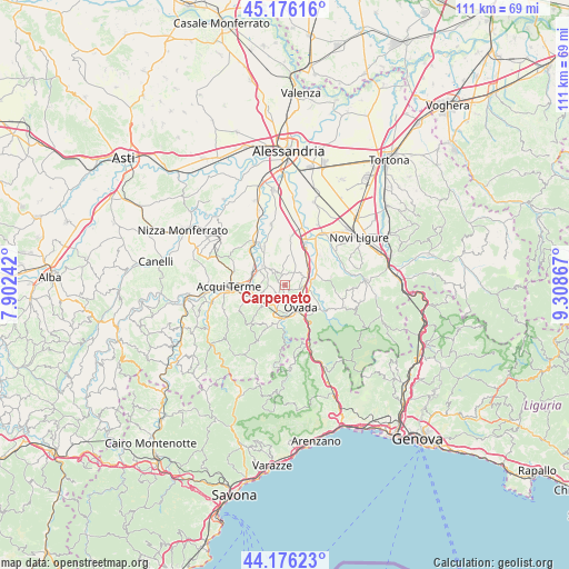
Carpeneto GPS coordinates[2]
44° 40' 42.06" North, 8° 36' 19.98" East
| Map corner | latitude | longitude |
|---|---|---|
| Upper-left | 45.17616°, | 7.90242° |
| Center: | 44.67835°, | 8.60555° |
| Lower-right: | 44.17623°, | 9.30867° |
| Map W x H: | 111.2×111.2 km | = 69.1×69.1mi |
| max Lat: | 47.04031° ⇑46.2% North |
| Carpeneto: | 44.67835° |
| min Lat: | ⇓53.8% South 35.50142° |
| min Long | Carpeneto | max Long |
| 6.69888° | 8.60555° | 18.48682° |
| W 13.4%⇐ | ⇒86.6% E |
Elevation
Elevation of Carpeneto is 330 m = 1083 ft, and this is 23.3 m = 76 ft above average elevation for this country.
| Max E: |
2085 m = 6841 ft | 36.3% |
| Carpeneto | 330 m 1083 ft | |
| Avg. | 306.7 m = 1006 ft | |
Min E: |
-4 m = -13 ft | 63.7% |
See also: Italy elevation on elevation.city.
Geographical zone
Carpeneto is located in North temperate zone (between Tropic of Cancer and the Arctic Circle). Distance of this Northern Tropic circle is 2361.8 km =1467.6 mi to South.| Distance of | km | miles | from Carpeneto |
|---|---|---|---|
| North Pole | 5039.3 | 3131.3 | to North |
| Arctic Circle | 2433.4 | 1512 | to North |
| Tropic Cancer | 2361.8 | 1467.6 | to South |
| Equator | 4967.8 | 3086.8 | to South |


Nearby cities:
15 places around Carpeneto: (largest is in red/bold)
• Belforte Monferrato
7.4 km =4.6 mi,  143°
143°
• Castelletto d'Orba
7.8 km =4.8 mi,  84°
84°
• Cremolino
4.9 km =3 mi,  198°
198°
• Molare
6.7 km =4.2 mi,  184°
184°
• Montaldo Bormida
1.5 km =0.9 mi,  288°
288°
• Morsasco
4.6 km =2.9 mi,  251°
251°
• Orsara Bormida
3.6 km =2.2 mi, 291°
• Ovada
5.4 km =3.4 mi,  147°
147°
• Prasco
6.1 km =3.8 mi,  224°
224°
• Rivalta Bormida
5.5 km =3.4 mi,  309°
309°
• Rocca Grimalda
3.5 km =2.2 mi,  102°
102°
• Silvano d'Orba
5.3 km =3.3 mi, 81°
• Strevi
6.8 km =4.2 mi, 290°
• Tagliolo Monferrato
6.5 km =4 mi,  133°
133°
• Trisobbio
2.5 km =1.6 mi, 217°
Sources, notices
• [Note1] Compared only with cities in Italy existing in our database
• [Src1] Map data: © OpenStreetMap contributors (CC-BY-SA)
• [Src2] Other city data from geonames.org with taken over terms of usage.
• [Src3] Geographical zone / Annual Mean Temperature by Robert A. Rohde @ Wikipedia
