Olivola geodata
Olivola (Piedmont) is a seat of a third-order administrative division; located in Italy in Europe/Rome (GMT+2) time zone. With population of 92 people, there are 11467 cities with bigger population in this country. Compared to other cities in Italy, 60.9% of cities are located further ↓South; 89.4% of cities are located further →East and 55.7% of cities have lower elevation than Olivola. Note1


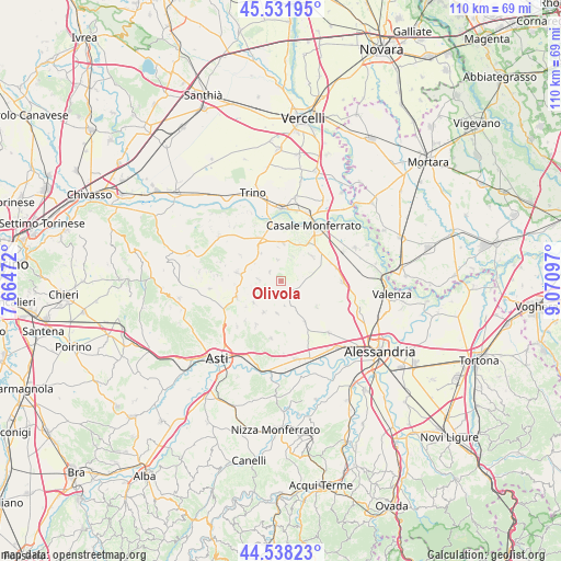
Olivola GPS coordinates[2]
45° 2' 14.1" North, 8° 22' 4.224" East
| Map corner | latitude | longitude |
|---|---|---|
| Upper-left | 45.53195°, | 7.66472° |
| Center: | 45.03725°, | 8.36784° |
| Lower-right: | 44.53823°, | 9.07097° |
| Map W x H: | 110.5×110.5 km | = 68.7×68.7mi |
| max Lat: | 47.04031° ⇑39.1% North |
| Olivola: | 45.03725° |
| min Lat: | ⇓60.9% South 35.50142° |
| min Long | Olivola | max Long |
| 6.69888° | 8.36784° | 18.48682° |
| W 10.6%⇐ | ⇒89.4% E |
Elevation
Elevation of Olivola is 270 m = 886 ft, and this is 36.7 m = 120 ft below average elevation for this country.
| Max E: |
2085 m = 6841 ft | 44.3% |
| Avg. | 306.7 m = 1006 ft | |
| Olivola | 270 m = 886 ft | |
Min E: |
-4 m = -13 ft | 55.7% |
See also: Italy elevation on elevation.city.
Geographical zone
Olivola is located in North temperate zone (between Tropic of Cancer and the Arctic Circle). Distance of this North polar circle is 2393.5 km =1487.3 mi to North.| Distance of | km | miles | from Olivola |
|---|---|---|---|
| North Pole | 4999.4 | 3106.5 | to North |
| Arctic Circle | 2393.5 | 1487.3 | to North |
| Tropic Cancer | 2401.8 | 1492.4 | to South |
| Equator | 5007.7 | 3111.6 | to South |


Nearby cities:
15 places around Olivola: (largest is in red/bold)
• Altavilla Monferrato
4.9 km =3 mi,  172°
172°
• Camagna Monferrato
5.3 km =3.3 mi,  114°
114°
• Casorzo
2.9 km =1.8 mi,  233°
233°
• Cella Monte
4.5 km =2.8 mi,  24°
24°
• Cereseto
6.8 km =4.2 mi,  324°
324°
• Frassinello Monferrato
1.5 km =0.9 mi, 106°
• Grana
6.9 km =4.3 mi, 231°
• Grazzano Badoglio
4.5 km =2.8 mi,  273°
273°
• Montemagno
6.9 km =4.3 mi,  209°
209°
• Ottiglio
2.9 km =1.8 mi,  310°
310°
• Rosignano Monferrato
5.4 km =3.4 mi,  27°
27°
• Sala Monferrato
4.3 km =2.7 mi,  352°
352°
• Treville
6.7 km =4.2 mi, 354°
• Viarigi
6.4 km =4 mi,  187°
187°
• Vignale Monferrato
3.8 km =2.4 mi,  142°
142°
Sources, notices
• [Note1] Compared only with cities in Italy existing in our database
• [Src1] Map data: © OpenStreetMap contributors (CC-BY-SA)
• [Src2] Other city data from geonames.org with taken over terms of usage.
• [Src3] Geographical zone / Annual Mean Temperature by Robert A. Rohde @ Wikipedia
