Masate geodata
Masate (Lombardy) is a seat of a third-order administrative division; located in Italy in Europe/Rome (GMT+2) time zone. With population of 3,295 people, there are 2843 cities with bigger population in this country. Compared to other cities in Italy, 75.8% of cities are located further ↓South; 73.7% of cities are located further →East and 62% of cities have higher elevation than Masate. Note1
Administrative division(s):
- Level 1: Lombardy
- Level 2: Città metropolitana di Milano
- Level 3: Masate


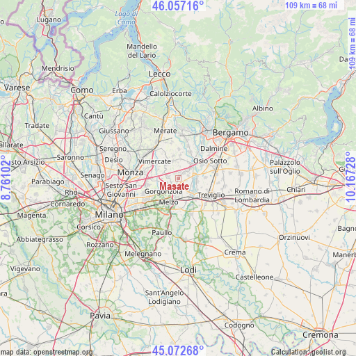
Masate GPS coordinates[2]
45° 34' 1.488" North, 9° 27' 50.94" East
| Map corner | latitude | longitude |
|---|---|---|
| Upper-left | 46.05716°, | 8.76102° |
| Center: | 45.56708°, | 9.46415° |
| Lower-right: | 45.07268°, | 10.16728° |
| Map W x H: | 109.5×109.5 km | = 68×68mi |
| max Lat: | 47.04031° ⇑24.2% North |
| Masate: | 45.56708° |
| min Lat: | ⇓75.8% South 35.50142° |
| min Long | Masate | max Long |
| 6.69888° | 9.46415° | 18.48682° |
| W 26.3%⇐ | ⇒73.7% E |
Elevation
Elevation of Masate is 149 m = 489 ft, and this is 157.7 m = 517 ft below average elevation for this country.
| Max E: |
2085 m = 6841 ft | 62% |
| Avg. | 306.7 m = 1006 ft | |
| Masate | 149 m = 489 ft | |
Min E: |
-4 m = -13 ft | 38% |
See also: Italy elevation on elevation.city.
Geographical zone
Masate is located in North temperate zone (between Tropic of Cancer and the Arctic Circle). Distance of this North polar circle is 2334.6 km =1450.7 mi to North.| Distance of | km | miles | from Masate |
|---|---|---|---|
| North Pole | 4940.5 | 3069.9 | to North |
| Arctic Circle | 2334.6 | 1450.7 | to North |
| Tropic Cancer | 2460.7 | 1529 | to South |
| Equator | 5066.6 | 3148.2 | to South |


Nearby cities:
15 places around Masate: (largest is in red/bold)
• Basiano
1.7 km =1.1 mi,  357°
357°
• Bellinzago Lombardo
3.1 km =1.9 mi,  207°
207°
• Busnago
5.5 km =3.4 mi, 359°
• Cambiago
2.7 km =1.7 mi,  303°
303°
• Cavenago di Brianza
4.4 km =2.7 mi,  293°
293°
• Gessate
2.9 km =1.8 mi,  224°
224°
• Grezzago
3.7 km =2.3 mi,  43°
43°
• Inzago
3.4 km =2.1 mi,  153°
153°
• Ornago
5 km =3.1 mi,  317°
317°
• Pozzo d'Adda
3.1 km =1.9 mi,  78°
78°
• Roncello
4 km =2.5 mi,  349°
349°
• Torrazza dei Mandelli
5.1 km =3.2 mi,  269°
269°
• Trezzano Rosa
2.4 km =1.5 mi, 44°
• Vaprio d'Adda
4.8 km =3 mi, 77°
• Villaggio Residenziale
4.3 km =2.7 mi,  176°
176°
Sources, notices
• [Note1] Compared only with cities in Italy existing in our database
• [Src1] Map data: © OpenStreetMap contributors (CC-BY-SA)
• [Src2] Other city data from geonames.org with taken over terms of usage.
• [Src3] Geographical zone / Annual Mean Temperature by Robert A. Rohde @ Wikipedia
