Ambivere geodata
Ambivere (Lombardy) is a seat of a third-order administrative division; located in Italy in Europe/Rome (GMT+2) time zone. With population of 1,879 people, there are 4358 cities with bigger population in this country. Compared to other cities in Italy, 82.2% of cities are located further ↓South; 72.6% of cities are located further →East and 54.6% of cities have lower elevation than Ambivere. Note1


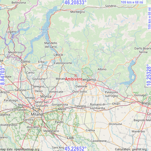
Ambivere GPS coordinates[2]
45° 43' 10.488" North, 9° 33' 0.54" East
| Map corner | latitude | longitude |
|---|---|---|
| Upper-left | 46.20833°, | 8.84703° |
| Center: | 45.71958°, | 9.55015° |
| Lower-right: | 45.22652°, | 10.25328° |
| Map W x H: | 109.2×109.2 km | = 67.9×67.9mi |
| max Lat: | 47.04031° ⇑17.8% North |
| Ambivere: | 45.71958° |
| min Lat: | ⇓82.2% South 35.50142° |
| min Long | Ambivere | max Long |
| 6.69888° | 9.55015° | 18.48682° |
| W 27.4%⇐ | ⇒72.6% E |
Elevation
Elevation of Ambivere is 263 m = 863 ft, and this is 43.7 m = 143 ft below average elevation for this country.
| Max E: |
2085 m = 6841 ft | 45.4% |
| Avg. | 306.7 m = 1006 ft | |
| Ambivere | 263 m = 863 ft | |
Min E: |
-4 m = -13 ft | 54.6% |
See also: Italy elevation on elevation.city.
Geographical zone
Ambivere is located in North temperate zone (between Tropic of Cancer and the Arctic Circle). Distance of this North polar circle is 2317.6 km =1440.1 mi to North.| Distance of | km | miles | from Ambivere |
|---|---|---|---|
| North Pole | 4923.5 | 3059.3 | to North |
| Arctic Circle | 2317.6 | 1440.1 | to North |
| Tropic Cancer | 2477.6 | 1539.5 | to South |
| Equator | 5083.5 | 3158.7 | to South |


Nearby cities:
15 places around Ambivere: (largest is in red/bold)
• Almenno San Bartolomeo
3.2 km =2 mi,  47°
47°
• Barzana
2.1 km =1.3 mi,  42°
42°
• Bonate Sopra
4.3 km =2.7 mi,  170°
170°
• Brembate di Sopra
2.3 km =1.4 mi,  98°
98°
• Gromlongo
1.3 km =0.8 mi,  325°
325°
• Mapello
0.8 km =0.5 mi,  156°
156°
• Palazzago
3.9 km =2.4 mi,  340°
340°
• Piazza Caduti
4 km =2.5 mi,  246°
246°
• Ponte San Pietro
3.5 km =2.2 mi,  115°
115°
• Pontida
3.3 km =2.1 mi,  293°
293°
• Pratolongo
3 km =1.9 mi, 248°
• Presezzo
3.4 km =2.1 mi,  152°
152°
• Sotto il Monte Giovanni XXIII
3.9 km =2.4 mi, 246°
• Terno d'Isola
4.1 km =2.5 mi,  201°
201°
• Valtrighe
2.9 km =1.8 mi, 201°
Sources, notices
• [Note1] Compared only with cities in Italy existing in our database
• [Src1] Map data: © OpenStreetMap contributors (CC-BY-SA)
• [Src2] Other city data from geonames.org with taken over terms of usage.
• [Src3] Geographical zone / Annual Mean Temperature by Robert A. Rohde @ Wikipedia
