Isera geodata
Isera (Trentino-Alto Adige) is a seat of a third-order administrative division; located in Italy in Europe/Rome (GMT+2) time zone. With population of 974 people, there are 6762 cities with bigger population in this country. Compared to other cities in Italy, 88.8% of cities are located further ↓South; 57.2% of cities are located further →East and 50% of cities have lower elevation than Isera. Note1
Administrative division(s):
- Level 1: Trentino-Alto Adige
- Level 2: Provincia autonoma di Trento
- Level 3: Isera


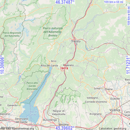
Isera GPS coordinates[2]
45° 53' 15.36" North, 11° 0' 33.048" East
| Map corner | latitude | longitude |
|---|---|---|
| Upper-left | 46.37487°, | 10.30606° |
| Center: | 45.8876°, | 11.00918° |
| Lower-right: | 45.39602°, | 11.71231° |
| Map W x H: | 108.8×108.8 km | = 67.6×67.6mi |
| max Lat: | 47.04031° ⇑11.2% North |
| Isera: | 45.8876° |
| min Lat: | ⇓88.8% South 35.50142° |
| min Long | Isera | max Long |
| 6.69888° | 11.00918° | 18.48682° |
| W 42.8%⇐ | ⇒57.2% E |
Elevation
Elevation of Isera is 235 m = 771 ft, and this is 71.7 m = 235 ft below average elevation for this country.
| Max E: |
2085 m = 6841 ft | 50% |
| Avg. | 306.7 m = 1006 ft | |
| Isera | 235 m = 771 ft | |
Min E: |
-4 m = -13 ft | 50% |
See also: Italy elevation on elevation.city.
Geographical zone
Isera is located in North temperate zone (between Tropic of Cancer and the Arctic Circle). Distance of this North polar circle is 2299 km =1428.5 mi to North.| Distance of | km | miles | from Isera |
|---|---|---|---|
| North Pole | 4904.8 | 3047.7 | to North |
| Arctic Circle | 2299 | 1428.5 | to North |
| Tropic Cancer | 2496.3 | 1551.1 | to South |
| Equator | 5102.2 | 3170.4 | to South |


Nearby cities:
15 places around Isera: (largest is in red/bold)
• Calliano
8.3 km =5.2 mi,  52°
52°
• Castellano
4 km =2.5 mi,  357°
357°
• Crosano
8 km =5 mi,  200°
200°
• Marco
5 km =3.1 mi,  179°
179°
• Mori
4.6 km =2.9 mi,  209°
209°
• Moscheri
5.4 km =3.4 mi,  112°
112°
• Nogaredo
3 km =1.9 mi,  21°
21°
• Nomi
6.7 km =4.2 mi, 46°
• Pedersano
3.8 km =2.4 mi,  13°
13°
• Pomarolo
5.2 km =3.2 mi,  30°
30°
• Ronzo-Chienis
4.6 km =2.9 mi,  272°
272°
• Rovereto
2.4 km =1.5 mi,  82°
82°
• Trambileno
5.4 km =3.4 mi, 112°
• Villa Lagarina
3.9 km =2.4 mi, 28°
• Volano
5.3 km =3.3 mi, 51°
Sources, notices
• [Note1] Compared only with cities in Italy existing in our database
• [Src1] Map data: © OpenStreetMap contributors (CC-BY-SA)
• [Src2] Other city data from geonames.org with taken over terms of usage.
• [Src3] Geographical zone / Annual Mean Temperature by Robert A. Rohde @ Wikipedia
