Terzo geodata
Terzo (Piedmont) is a seat of a third-order administrative division; located in Italy in Europe/Rome (GMT+2) time zone. With population of 428 people, there are 10171 cities with bigger population in this country. Compared to other cities in Italy, 53.7% of cities are located further ↓South; 88.8% of cities are located further →East and 53.6% of cities have higher elevation than Terzo. Note1


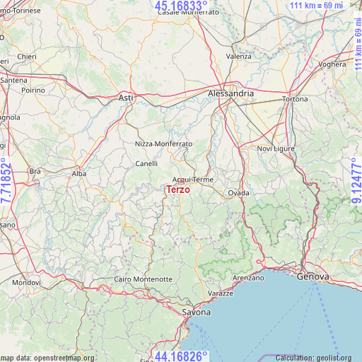
Terzo GPS coordinates[2]
44° 40' 13.62" North, 8° 25' 17.904" East
| Map corner | latitude | longitude |
|---|---|---|
| Upper-left | 45.16833°, | 7.71852° |
| Center: | 44.67045°, | 8.42164° |
| Lower-right: | 44.16826°, | 9.12477° |
| Map W x H: | 111.2×111.2 km | = 69.1×69.1mi |
| max Lat: | 47.04031° ⇑46.3% North |
| Terzo: | 44.67045° |
| min Lat: | ⇓53.7% South 35.50142° |
| min Long | Terzo | max Long |
| 6.69888° | 8.42164° | 18.48682° |
| W 11.2%⇐ | ⇒88.8% E |
Elevation
Elevation of Terzo is 212 m = 696 ft, and this is 94.7 m = 311 ft below average elevation for this country.
| Max E: |
2085 m = 6841 ft | 53.6% |
| Avg. | 306.7 m = 1006 ft | |
| Terzo | 212 m = 696 ft | |
Min E: |
-4 m = -13 ft | 46.4% |
See also: Italy elevation on elevation.city.
Geographical zone
Terzo is located in North temperate zone (between Tropic of Cancer and the Arctic Circle). Distance of this Northern Tropic circle is 2361 km =1467.1 mi to South.| Distance of | km | miles | from Terzo |
|---|---|---|---|
| North Pole | 5040.2 | 3131.8 | to North |
| Arctic Circle | 2434.3 | 1512.6 | to North |
| Tropic Cancer | 2361 | 1467.1 | to South |
| Equator | 4966.9 | 3086.3 | to South |


Nearby cities:
15 places around Terzo: (largest is in red/bold)
• Acqui Terme
3.8 km =2.4 mi,  81°
81°
• Alice Bel Colle
6.6 km =4.1 mi,  20°
20°
• Bistagno
4.1 km =2.5 mi,  254°
254°
• Castel Boglione
6.6 km =4.1 mi,  330°
330°
• Castel Rocchero
5.3 km =3.3 mi,  354°
354°
• Castelletto d'Erro
5.4 km =3.4 mi,  203°
203°
• Cavatore
5 km =3.1 mi,  150°
150°
• Grognardo
7.2 km =4.5 mi,  128°
128°
• Melazzo
3 km =1.9 mi,  174°
174°
• Montabone
4 km =2.5 mi,  322°
322°
• Ponti
6.5 km =4 mi,  224°
224°
• Ricaldone
7.8 km =4.8 mi,  28°
28°
• Rocchetta Palafea
7.3 km =4.5 mi,  304°
304°
• Sessame
6.7 km =4.2 mi,  270°
270°
• Visone
6.3 km =3.9 mi,  98°
98°
Sources, notices
• [Note1] Compared only with cities in Italy existing in our database
• [Src1] Map data: © OpenStreetMap contributors (CC-BY-SA)
• [Src2] Other city data from geonames.org with taken over terms of usage.
• [Src3] Geographical zone / Annual Mean Temperature by Robert A. Rohde @ Wikipedia
