Soriso geodata
Soriso (Piedmont) is a seat of a third-order administrative division; located in Italy in Europe/Rome (GMT+2) time zone. With population of 704 people, there are 8273 cities with bigger population in this country. Compared to other cities in Italy, 83.1% of cities are located further ↓South; 89% of cities are located further →East and 74.2% of cities have lower elevation than Soriso. Note1


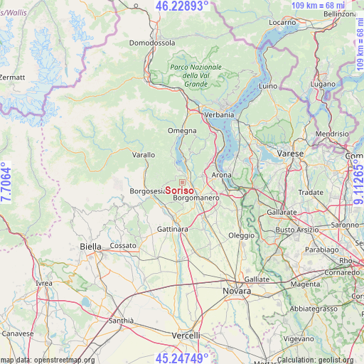
Soriso GPS coordinates[2]
45° 44' 25.332" North, 8° 24' 34.308" East
| Map corner | latitude | longitude |
|---|---|---|
| Upper-left | 46.22893°, | 7.7064° |
| Center: | 45.74037°, | 8.40953° |
| Lower-right: | 45.24749°, | 9.11265° |
| Map W x H: | 109.1×109.1 km | = 67.8×67.8mi |
| max Lat: | 47.04031° ⇑16.9% North |
| Soriso: | 45.74037° |
| min Lat: | ⇓83.1% South 35.50142° |
| min Long | Soriso | max Long |
| 6.69888° | 8.40953° | 18.48682° |
| W 11%⇐ | ⇒89% E |
Elevation
Elevation of Soriso is 442 m = 1450 ft, and this is 135.3 m = 444 ft above average elevation for this country.
| Max E: |
2085 m = 6841 ft | 25.8% |
| Soriso | 442 m 1450 ft | |
| Avg. | 306.7 m = 1006 ft | |
Min E: |
-4 m = -13 ft | 74.2% |
See also: Italy elevation on elevation.city.
Geographical zone
Soriso is located in North temperate zone (between Tropic of Cancer and the Arctic Circle). Distance of this North polar circle is 2315.3 km =1438.7 mi to North.| Distance of | km | miles | from Soriso |
|---|---|---|---|
| North Pole | 4921.2 | 3057.9 | to North |
| Arctic Circle | 2315.3 | 1438.7 | to North |
| Tropic Cancer | 2479.9 | 1540.9 | to South |
| Equator | 5085.9 | 3160.2 | to South |


Nearby cities:
15 places around Soriso: (largest is in red/bold)
• Ameno
5.9 km =3.7 mi,  23°
23°
• Barquedo
6.7 km =4.2 mi,  87°
87°
• Bolzano Novarese
3.6 km =2.2 mi,  45°
45°
• Borgomanero
6.2 km =3.9 mi,  138°
138°
• Briga Novarese
3.8 km =2.4 mi,  108°
108°
• Gargallo
1.8 km =1.1 mi, 136°
• Gozzano
2.1 km =1.3 mi,  82°
82°
• Invorio
6.3 km =3.9 mi,  73°
73°
• Madonna del Sasso
6.5 km =4 mi,  331°
331°
• Maggiora
5.8 km =3.6 mi,  170°
170°
• Orta San Giulio
6.3 km =3.9 mi,  3°
3°
• Pella
6.6 km =4.1 mi,  342°
342°
• Pogno
2.7 km =1.7 mi,  316°
316°
• San Maurizio D'Opaglio
3.8 km =2.4 mi, 343°
• Valduggia
6.5 km =4 mi,  257°
257°
Sources, notices
• [Note1] Compared only with cities in Italy existing in our database
• [Src1] Map data: © OpenStreetMap contributors (CC-BY-SA)
• [Src2] Other city data from geonames.org with taken over terms of usage.
• [Src3] Geographical zone / Annual Mean Temperature by Robert A. Rohde @ Wikipedia
