Lugnacco geodata
Lugnacco (Piedmont) is a seat of a third-order administrative division; located in Italy in Europe/Rome (GMT+2) time zone. With population of 265 people, there are 10827 cities with bigger population in this country. Compared to other cities in Italy, 71.8% of cities are located further ↓South; 95.7% of cities are located further →East and 82.7% of cities have lower elevation than Lugnacco. Note1


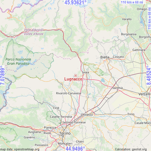
Lugnacco GPS coordinates[2]
45° 26' 42.216" North, 7° 46' 55.632" East
| Map corner | latitude | longitude |
|---|---|---|
| Upper-left | 45.93621°, | 7.07899° |
| Center: | 45.44506°, | 7.78212° |
| Lower-right: | 44.9496°, | 8.48524° |
| Map W x H: | 109.7×109.7 km | = 68.2×68.2mi |
| max Lat: | 47.04031° ⇑28.2% North |
| Lugnacco: | 45.44506° |
| min Lat: | ⇓71.8% South 35.50142° |
| min Long | Lugnacco | max Long |
| 6.69888° | 7.78212° | 18.48682° |
| W 4.3%⇐ | ⇒95.7% E |
Elevation
Elevation of Lugnacco is 567 m = 1860 ft, and this is 260.3 m = 854 ft above average elevation for this country.
| Max E: |
2085 m = 6841 ft | 17.3% |
| Lugnacco | 567 m 1860 ft | |
| Avg. | 306.7 m = 1006 ft | |
Min E: |
-4 m = -13 ft | 82.7% |
See also: Italy elevation on elevation.city.
Geographical zone
Lugnacco is located in North temperate zone (between Tropic of Cancer and the Arctic Circle). Distance of this North polar circle is 2348.2 km =1459.1 mi to North.| Distance of | km | miles | from Lugnacco |
|---|---|---|---|
| North Pole | 4954 | 3078.3 | to North |
| Arctic Circle | 2348.2 | 1459.1 | to North |
| Tropic Cancer | 2447.1 | 1520.6 | to South |
| Equator | 5053 | 3139.8 | to South |


Nearby cities:
15 places around Lugnacco: (largest is in red/bold)
• Alice Superiore
1.7 km =1.1 mi,  352°
352°
• Baldissero Canavese
4.9 km =3 mi,  217°
217°
• Colleretto Giacosa
1.9 km =1.2 mi,  136°
136°
• Fiorano Canavese
4.8 km =3 mi,  57°
57°
• Issiglio
2.3 km =1.4 mi,  273°
273°
• Lessolo
4.5 km =2.8 mi,  35°
35°
• Loranzè
2.4 km =1.5 mi,  96°
96°
• Parella
1.8 km =1.1 mi,  156°
156°
• Pecco
0.9 km =0.6 mi,  334°
334°
• Quagliuzzo
2.1 km =1.3 mi,  182°
182°
• Rueglio
3.4 km =2.1 mi,  320°
320°
• Samone
4.7 km =2.9 mi,  84°
84°
• Strambinello
2.6 km =1.6 mi,  201°
201°
• Vidracco
2.5 km =1.6 mi,  230°
230°
• Vistrorio
1.2 km =0.7 mi,  250°
250°
Sources, notices
• [Note1] Compared only with cities in Italy existing in our database
• [Src1] Map data: © OpenStreetMap contributors (CC-BY-SA)
• [Src2] Other city data from geonames.org with taken over terms of usage.
• [Src3] Geographical zone / Annual Mean Temperature by Robert A. Rohde @ Wikipedia
