Mornese geodata
Mornese (Piedmont) is a seat of a third-order administrative division; located in Italy in Europe/Rome (GMT+2) time zone. With population of 520 people, there are 9731 cities with bigger population in this country. Compared to other cities in Italy, 53.2% of cities are located further ↓South; 84.7% of cities are located further →East and 67.5% of cities have lower elevation than Mornese. Note1


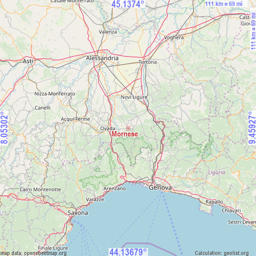
Mornese GPS coordinates[2]
44° 38' 21.3" North, 8° 45' 22.14" East
| Map corner | latitude | longitude |
|---|---|---|
| Upper-left | 45.1374°, | 8.05302° |
| Center: | 44.63925°, | 8.75615° |
| Lower-right: | 44.13679°, | 9.45927° |
| Map W x H: | 111.3×111.3 km | = 69.2×69.2mi |
| max Lat: | 47.04031° ⇑46.8% North |
| Mornese: | 44.63925° |
| min Lat: | ⇓53.2% South 35.50142° |
| min Long | Mornese | max Long |
| 6.69888° | 8.75615° | 18.48682° |
| W 15.3%⇐ | ⇒84.7% E |
Elevation
Elevation of Mornese is 368 m = 1207 ft, and this is 61.3 m = 201 ft above average elevation for this country.
| Max E: |
2085 m = 6841 ft | 32.5% |
| Mornese | 368 m 1207 ft | |
| Avg. | 306.7 m = 1006 ft | |
Min E: |
-4 m = -13 ft | 67.5% |
See also: Italy elevation on elevation.city.
Geographical zone
Mornese is located in North temperate zone (between Tropic of Cancer and the Arctic Circle). Distance of this Northern Tropic circle is 2357.5 km =1464.9 mi to South.| Distance of | km | miles | from Mornese |
|---|---|---|---|
| North Pole | 5043.6 | 3133.9 | to North |
| Arctic Circle | 2437.8 | 1514.8 | to North |
| Tropic Cancer | 2357.5 | 1464.9 | to South |
| Equator | 4963.4 | 3084.1 | to South |


Nearby cities:
15 places around Mornese: (largest is in red/bold)
• Belforte Monferrato
7.7 km =4.8 mi,  258°
258°
• Bosio
3.1 km =1.9 mi,  68°
68°
• Carrosio
6.3 km =3.9 mi, 70°
• Casaleggio Boiro
2.1 km =1.3 mi,  252°
252°
• Castelletto d'Orba
6.5 km =4 mi,  320°
320°
• Gavi
6.6 km =4.1 mi,  37°
37°
• Lerma
3.4 km =2.1 mi, 263°
• Montaldeo
3.7 km =2.3 mi,  326°
326°
• Ovada
9 km =5.6 mi,  268°
268°
• Parodi Ligure
3.4 km =2.1 mi,  3°
3°
• Rocca Grimalda
9.2 km =5.7 mi,  292°
292°
• San Cristoforo
6 km =3.7 mi,  354°
354°
• Silvano d'Orba
8.4 km =5.2 mi,  307°
307°
• Tagliolo Monferrato
7.1 km =4.4 mi, 269°
• Voltaggio
7.1 km =4.4 mi,  106°
106°
Sources, notices
• [Note1] Compared only with cities in Italy existing in our database
• [Src1] Map data: © OpenStreetMap contributors (CC-BY-SA)
• [Src2] Other city data from geonames.org with taken over terms of usage.
• [Src3] Geographical zone / Annual Mean Temperature by Robert A. Rohde @ Wikipedia
