Ispani geodata
Ispani (Campania) is a seat of a third-order administrative division; located in Italy in Europe/Rome (GMT+2) time zone. With population of 131 people, there are 11347 cities with bigger population in this country. Compared to other cities in Italy, 87.3% of cities are located further ↑North; 90.8% of cities are located further ←West and 53% of cities have lower elevation than Ispani. Note1


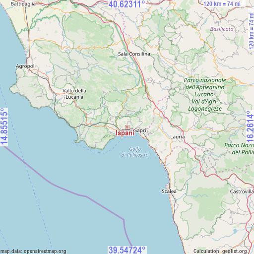
Ispani GPS coordinates[2]
40° 5' 14.28" North, 15° 33' 29.772" East
| Map corner | latitude | longitude |
|---|---|---|
| Upper-left | 40.62311°, | 14.85515° |
| Center: | 40.0873°, | 15.55827° |
| Lower-right: | 39.54724°, | 16.2614° |
| Map W x H: | 119.6×119.6 km | = 74.3×74.3mi |
| max Lat: | 47.04031° ⇑87.3% North |
| Ispani: | 40.0873° |
| min Lat: | ⇓12.7% South 35.50142° |
| min Long | Ispani | max Long |
| 6.69888° | 15.55827° | 18.48682° |
| W 90.8%⇐ | ⇒9.2% E |
Elevation
Elevation of Ispani is 253 m = 830 ft, and this is 53.7 m = 176 ft below average elevation for this country.
| Max E: |
2085 m = 6841 ft | 47% |
| Avg. | 306.7 m = 1006 ft | |
| Ispani | 253 m = 830 ft | |
Min E: |
-4 m = -13 ft | 53% |
See also: Italy elevation on elevation.city.
Geographical zone
Ispani is located in North temperate zone (between Tropic of Cancer and the Arctic Circle). Distance of this Northern Tropic circle is 1851.4 km =1150.4 mi to South.| Distance of | km | miles | from Ispani |
|---|---|---|---|
| North Pole | 5549.8 | 3448.5 | to North |
| Arctic Circle | 2943.9 | 1829.3 | to North |
| Tropic Cancer | 1851.4 | 1150.4 | to South |
| Equator | 4457.3 | 2769.6 | to South |


Nearby cities:
15 places around Ispani: (largest is in red/bold)
• Acquavena
9.6 km =6 mi,  267°
267°
• Capitello
1.4 km =0.9 mi,  212°
212°
• Casaletto Spartano
8.9 km =5.5 mi,  36°
36°
• Caselle in Pittari
9.6 km =6 mi,  352°
352°
• Morigerati
5.9 km =3.7 mi,  357°
357°
• Policastro Bussentino
3.4 km =2.1 mi,  246°
246°
• San Giovanni A Piro
10.3 km =6.4 mi, 247°
• Santa Marina
2.4 km =1.5 mi,  324°
324°
• Sapri
6.4 km =4 mi,  102°
102°
• Scario
7.7 km =4.8 mi, 248°
• Torraca
7.1 km =4.4 mi,  68°
68°
• Torre Orsaia
8.9 km =5.5 mi,  304°
304°
• Tortorella
7.4 km =4.6 mi,  33°
33°
• Vibonati
2.5 km =1.6 mi,  58°
58°
• Villammare
3.2 km =2 mi,  109°
109°
Sources, notices
• [Note1] Compared only with cities in Italy existing in our database
• [Src1] Map data: © OpenStreetMap contributors (CC-BY-SA)
• [Src2] Other city data from geonames.org with taken over terms of usage.
• [Src3] Geographical zone / Annual Mean Temperature by Robert A. Rohde @ Wikipedia
