Cigliè geodata
Cigliè (Piedmont) is a seat of a third-order administrative division; located in Italy in Europe/Rome (GMT+2) time zone. With population of 50 people, there are 11602 cities with bigger population in this country. Compared to other cities in Italy, 50.1% of cities are located further ↓South; 94.5% of cities are located further →East and 80.7% of cities have lower elevation than Cigliè. Note1


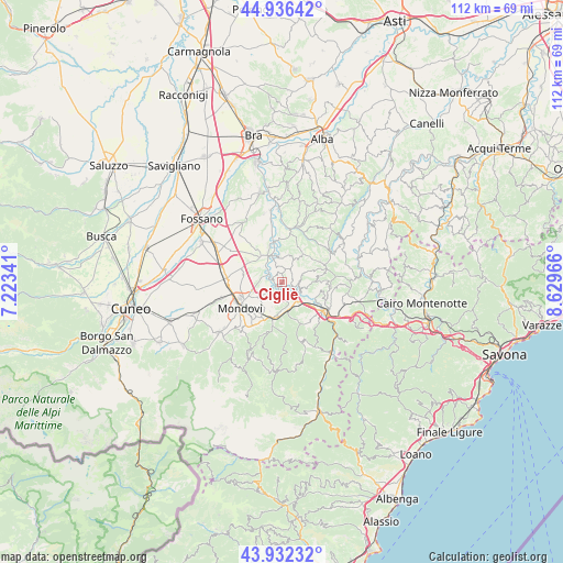
Cigliè GPS coordinates[2]
44° 26' 11.508" North, 7° 55' 35.544" East
| Map corner | latitude | longitude |
|---|---|---|
| Upper-left | 44.93642°, | 7.22341° |
| Center: | 44.43653°, | 7.92654° |
| Lower-right: | 43.93232°, | 8.62966° |
| Map W x H: | 111.6×111.6 km | = 69.3×69.3mi |
| max Lat: | 47.04031° ⇑49.9% North |
| Cigliè: | 44.43653° |
| min Lat: | ⇓50.1% South 35.50142° |
| min Long | Cigliè | max Long |
| 6.69888° | 7.92654° | 18.48682° |
| W 5.5%⇐ | ⇒94.5% E |
Elevation
Elevation of Cigliè is 535 m = 1755 ft, and this is 228.3 m = 749 ft above average elevation for this country.
| Max E: |
2085 m = 6841 ft | 19.3% |
| Cigliè | 535 m 1755 ft | |
| Avg. | 306.7 m = 1006 ft | |
Min E: |
-4 m = -13 ft | 80.7% |
See also: Italy elevation on elevation.city.
Geographical zone
Cigliè is located in North temperate zone (between Tropic of Cancer and the Arctic Circle). Distance of this Northern Tropic circle is 2335 km =1450.9 mi to South.| Distance of | km | miles | from Cigliè |
|---|---|---|---|
| North Pole | 5066.2 | 3148 | to North |
| Arctic Circle | 2460.3 | 1528.8 | to North |
| Tropic Cancer | 2335 | 1450.9 | to South |
| Equator | 4940.9 | 3070.1 | to South |


Nearby cities:
15 places around Cigliè: (largest is in red/bold)
• Bastia Mondovì
2.6 km =1.6 mi,  283°
283°
• Belvedere Langhe
7.4 km =4.6 mi,  30°
30°
• Borgo
3.6 km =2.2 mi,  164°
164°
• Briaglia
6.1 km =3.8 mi,  221°
221°
• Carrù
6.4 km =4 mi,  318°
318°
• Castellino Tanaro
4.4 km =2.7 mi,  102°
102°
• Clavesana
5.4 km =3.4 mi,  346°
346°
• Igliano
6.9 km =4.3 mi,  84°
84°
• Lesegno
5.2 km =3.2 mi,  139°
139°
• Marsaglia
4.6 km =2.9 mi,  66°
66°
• Murazzano
8.4 km =5.2 mi,  60°
60°
• Niella Tanaro
3.4 km =2.1 mi,  178°
178°
• Roascio
7.9 km =4.9 mi,  105°
105°
• Rocca Cigliè
2.2 km =1.4 mi, 63°
• San Michele Mondovì
6.9 km =4.3 mi,  192°
192°
Sources, notices
• [Note1] Compared only with cities in Italy existing in our database
• [Src1] Map data: © OpenStreetMap contributors (CC-BY-SA)
• [Src2] Other city data from geonames.org with taken over terms of usage.
• [Src3] Geographical zone / Annual Mean Temperature by Robert A. Rohde @ Wikipedia
