Ca' Savio geodata
Ca' Savio (Veneto) is a seat of a third-order administrative division; located in Italy in Europe/Rome (GMT+2) time zone. With population of 5,737 people, there are 1715 cities with bigger population in this country. Compared to other cities in Italy, 72% of cities are located further ↓South; 61.9% of cities are located further ←West and 98.4% of cities have higher elevation than Ca' Savio. Note1
Administrative division(s):
- Level 1: Veneto
- Level 2: Provincia di Venezia
- Level 3: Cavallino-Treporti


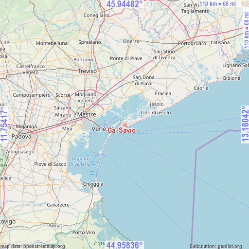
Ca' Savio GPS coordinates[2]
45° 27' 13.5" North, 12° 27' 26.244" East
| Map corner | latitude | longitude |
|---|---|---|
| Upper-left | 45.94482°, | 11.75417° |
| Center: | 45.45375°, | 12.45729° |
| Lower-right: | 44.95836°, | 13.16042° |
| Map W x H: | 109.7×109.7 km | = 68.2×68.2mi |
| max Lat: | 47.04031° ⇑28% North |
| Ca' Savio: | 45.45375° |
| min Lat: | ⇓72% South 35.50142° |
| min Long | Ca' Savio | max Long |
| 6.69888° | 12.45729° | 18.48682° |
| W 61.9%⇐ | ⇒38.1% E |
Elevation
Elevation of Ca' Savio is 3 m = 10 ft, and this is 303.7 m = 996 ft below average elevation for this country.
| Max E: |
2085 m = 6841 ft | 98.4% |
| Avg. | 306.7 m = 1006 ft | |
| Ca' Savio | 3 m = 10 ft | |
Min E: |
-4 m = -13 ft | 1.6% |
See also: Italy elevation on elevation.city.
Geographical zone
Ca' Savio is located in North temperate zone (between Tropic of Cancer and the Arctic Circle). Distance of this North polar circle is 2347.2 km =1458.5 mi to North.| Distance of | km | miles | from Ca' Savio |
|---|---|---|---|
| North Pole | 4953.1 | 3077.7 | to North |
| Arctic Circle | 2347.2 | 1458.5 | to North |
| Tropic Cancer | 2448.1 | 1521.2 | to South |
| Equator | 5054 | 3140.4 | to South |


Nearby cities:
15 places around Ca' Savio: (largest is in red/bold)
• Bagaron
13.6 km =8.5 mi,  284°
284°
• Burano
4.7 km =2.9 mi,  318°
318°
• Ca' Ballarin
4.7 km =2.9 mi,  70°
70°
• Ca' Corner
11.8 km =7.3 mi,  351°
351°
• Campalto
13.6 km =8.5 mi, 282°
• Cavallino
7.5 km =4.7 mi, 71°
• Giudecca
10.5 km =6.5 mi,  252°
252°
• Lido
8.6 km =5.3 mi,  235°
235°
• Murano
7.9 km =4.9 mi,  273°
273°
• Punta Sabbioni
2.6 km =1.6 mi, 253°
• San Liberale
13.8 km =8.6 mi, 319°
• San Martino Destra
4.7 km =2.9 mi, 319°
• San Martino Sinistrac
4.7 km =2.9 mi, 317°
• Tessera
11.6 km =7.2 mi,  297°
297°
• Venice
9.9 km =6.2 mi,  259°
259°
Sources, notices
• [Note1] Compared only with cities in Italy existing in our database
• [Src1] Map data: © OpenStreetMap contributors (CC-BY-SA)
• [Src2] Other city data from geonames.org with taken over terms of usage.
• [Src3] Geographical zone / Annual Mean Temperature by Robert A. Rohde @ Wikipedia
