Sambuceto geodata
Sambuceto (Abruzzo) is a seat of a third-order administrative division; located in Italy in Europe/Rome (GMT+2) time zone. With population of 9,596 people, there are 985 cities with bigger population in this country. Compared to other cities in Italy, 66.7% of cities are located further ↑North; 79.7% of cities are located further ←West and 90.6% of cities have higher elevation than Sambuceto. Note1
Administrative division(s):
- Level 1: Abruzzo
- Level 2: Provincia di Chieti
- Level 3: San Giovanni Teatino


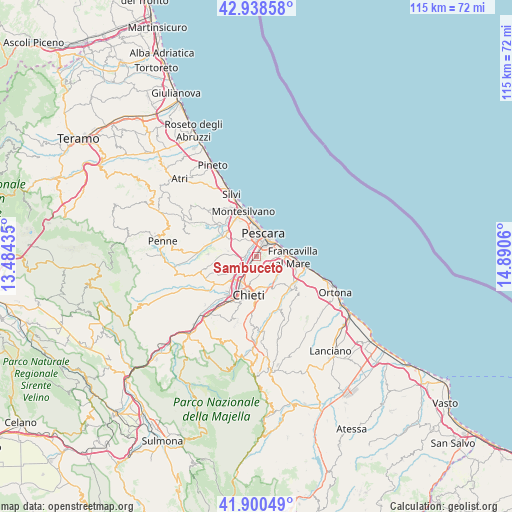
Sambuceto GPS coordinates[2]
42° 25' 18.048" North, 14° 11' 14.892" East
| Map corner | latitude | longitude |
|---|---|---|
| Upper-left | 42.93858°, | 13.48435° |
| Center: | 42.42168°, | 14.18747° |
| Lower-right: | 41.90049°, | 14.8906° |
| Map W x H: | 115.4×115.4 km | = 71.7×71.7mi |
| max Lat: | 47.04031° ⇑66.7% North |
| Sambuceto: | 42.42168° |
| min Lat: | ⇓33.3% South 35.50142° |
| min Long | Sambuceto | max Long |
| 6.69888° | 14.18747° | 18.48682° |
| W 79.7%⇐ | ⇒20.3% E |
Elevation
Elevation of Sambuceto is 17 m = 56 ft, and this is 289.7 m = 950 ft below average elevation for this country.
| Max E: |
2085 m = 6841 ft | 90.6% |
| Avg. | 306.7 m = 1006 ft | |
| Sambuceto | 17 m = 56 ft | |
Min E: |
-4 m = -13 ft | 9.4% |
See also: Italy elevation on elevation.city.
Geographical zone
Sambuceto is located in North temperate zone (between Tropic of Cancer and the Arctic Circle). Distance of this Northern Tropic circle is 2110.9 km =1311.7 mi to South.| Distance of | km | miles | from Sambuceto |
|---|---|---|---|
| North Pole | 5290.2 | 3287.2 | to North |
| Arctic Circle | 2684.3 | 1667.9 | to North |
| Tropic Cancer | 2110.9 | 1311.7 | to South |
| Equator | 4716.8 | 2930.9 | to South |


Nearby cities:
15 places around Sambuceto: (largest is in red/bold)
• Caprara d'Abruzzo
6.4 km =4 mi,  280°
280°
• Castelferrato
5.6 km =3.5 mi,  150°
150°
• Castellana
7 km =4.3 mi,  248°
248°
• Cerratina
7.7 km =4.8 mi,  243°
243°
• Chieti
8.4 km =5.2 mi,  192°
192°
• Francavilla al Mare
7.8 km =4.8 mi,  90°
90°
• Montesilvano Colle
8.4 km =5.2 mi,  335°
335°
• Parco
0.9 km =0.6 mi,  180°
180°
• Pescara
4.3 km =2.7 mi,  17°
17°
• Ripa Teatina
7.8 km =4.8 mi,  142°
142°
• Santa Teresa
2.5 km =1.6 mi,  285°
285°
• Spoltore
5.4 km =3.4 mi,  313°
313°
• Torrevecchia
4.8 km =3 mi, 153°
• Villa Raspa
3.8 km =2.4 mi,  356°
356°
• Villanova
6.8 km =4.2 mi,  230°
230°
Sources, notices
• [Note1] Compared only with cities in Italy existing in our database
• [Src1] Map data: © OpenStreetMap contributors (CC-BY-SA)
• [Src2] Other city data from geonames.org with taken over terms of usage.
• [Src3] Geographical zone / Annual Mean Temperature by Robert A. Rohde @ Wikipedia
