Cannizzaro-Favara geodata
Cannizzaro-Favara (Sicily) is a populated place; located in Italy in Europe/Rome (GMT+2) time zone. With population of 1,283 people, there are 5687 cities with bigger population in this country. Compared to other cities in Italy, 96% of cities are located further ↑North; 71.1% of cities are located further ←West and 60% of cities have lower elevation than Cannizzaro-Favara. Note1


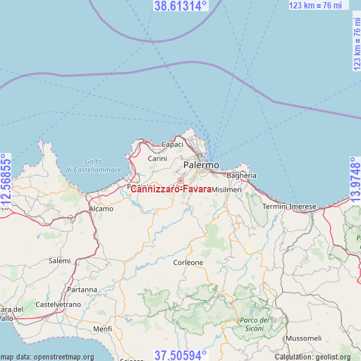
Cannizzaro-Favara GPS coordinates[2]
38° 3' 41.868" North, 13° 16' 18.012" East
| Map corner | latitude | longitude |
|---|---|---|
| Upper-left | 38.61314°, | 12.56855° |
| Center: | 38.06163°, | 13.27167° |
| Lower-right: | 37.50594°, | 13.9748° |
| Map W x H: | 123.1×123.1 km | = 76.5×76.5mi |
| max Lat: | 47.04031° ⇑96% North |
| Cannizzaro-Favara: | 38.06163° |
| min Lat: | ⇓4% South 35.50142° |
| min Long | Cannizzaro-Fava | max Long |
| 6.69888° | 13.27167° | 18.48682° |
| W 71.1%⇐ | ⇒28.9% E |
Elevation
Elevation of Cannizzaro-Favara is 299 m = 981 ft, and this is 7.7 m = 25 ft below average elevation for this country.
| Max E: |
2085 m = 6841 ft | 40% |
| Avg. | 306.7 m = 1006 ft | |
| Cannizzaro-Favara | 299 m = 981 ft | |
Min E: |
-4 m = -13 ft | 60% |
See also: Italy elevation on elevation.city.
Geographical zone
Cannizzaro-Favara is located in North temperate zone (between Tropic of Cancer and the Arctic Circle). Distance of this Northern Tropic circle is 1626.1 km =1010.4 mi to South.| Distance of | km | miles | from Cannizzaro-Favara |
|---|---|---|---|
| North Pole | 5775 | 3588.4 | to North |
| Arctic Circle | 3169.1 | 1969.2 | to North |
| Tropic Cancer | 1626.1 | 1010.4 | to South |
| Equator | 4232.1 | 2629.7 | to South |


Nearby cities:
15 places around Cannizzaro-Favara: (largest is in red/bold)
• Altofonte
2.9 km =1.8 mi,  136°
136°
• Bellolampo
8.3 km =5.2 mi,  0°
0°
• Giacalone
4.4 km =2.7 mi,  223°
223°
• Giardinello
10.5 km =6.5 mi,  285°
285°
• Monreale
2.7 km =1.7 mi,  35°
35°
• Montelepre
9 km =5.6 mi, 290°
• Palermo
9.6 km =6 mi, 35°
• Piana degli Albanesi
7.6 km =4.7 mi,  171°
171°
• Piano Maglio-Blandino
3.3 km =2.1 mi,  97°
97°
• Piano dei Geli
4.2 km =2.6 mi, 3°
• Pioppo
3.6 km =2.2 mi,  248°
248°
• San Martino delle Scale
3.6 km =2.2 mi,  334°
334°
• Santa Cristina Gela
9.8 km =6.1 mi,  150°
150°
• Torretta
8.3 km =5.2 mi,  337°
337°
• Villa Ciambra
4.2 km =2.6 mi,  90°
90°
Sources, notices
• [Note1] Compared only with cities in Italy existing in our database
• [Src1] Map data: © OpenStreetMap contributors (CC-BY-SA)
• [Src2] Other city data from geonames.org with taken over terms of usage.
• [Src3] Geographical zone / Annual Mean Temperature by Robert A. Rohde @ Wikipedia
