Mataguži geodata
Mataguži (Podgorica) is a populated place; located in Montenegro in Europe/Podgorica (GMT+2) time zone. With population of 1,132 people, there are 33 cities with bigger population in this country. Compared to other cities in Montenegro, 84.1% of cities are located further ↑North; 76.2% of cities are located further ←West and 71.4% of cities have higher elevation than Mataguži. Note1


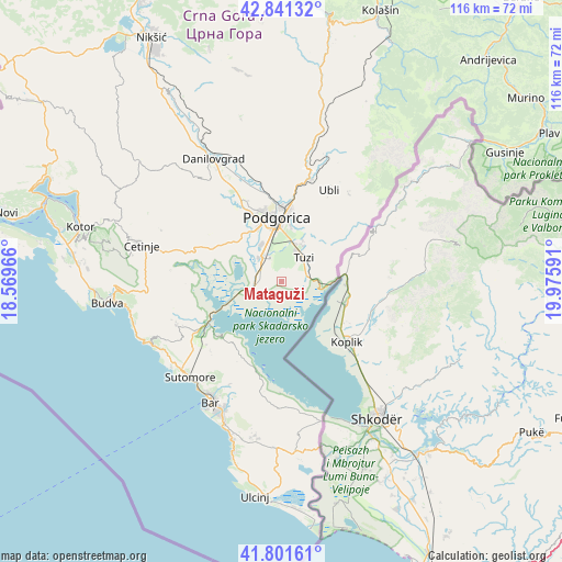
Mataguži GPS coordinates[2]
42° 19' 24.996" North, 19° 16' 22.008" East
| Map corner | latitude | longitude |
|---|---|---|
| Upper-left | 42.84132°, | 18.56966° |
| Center: | 42.32361°, | 19.27278° |
| Lower-right: | 41.80161°, | 19.97591° |
| Map W x H: | 115.6×115.6 km | = 71.8×71.8mi |
| max Lat: | 43.38472° ⇑84.1% North |
| Mataguži: | 42.32361° |
| min Lat: | ⇓15.9% South 41.92936° |
| min Long | Mataguži | max Long |
| 18.50647° | 19.27278° | 20.16652° |
| W 76.2%⇐ | ⇒23.8% E |
Elevation
Elevation of Mataguži is 16 m = 52 ft, and this is 330 m = 1083 ft below average elevation for this country.
| Max E: |
1448 m = 4751 ft | 71.4% |
| Avg. | 346 m = 1135 ft | |
| Mataguži | 16 m = 52 ft | |
Min E: |
4 m = 13 ft | 28.6% |
See also: Montenegro elevation on elevation.city.
Geographical zone
Mataguži is located in North temperate zone (between Tropic of Cancer and the Arctic Circle). Distance of this Northern Tropic circle is 2100 km =1304.9 mi to South.| Distance of | km | miles | from Mataguži |
|---|---|---|---|
| North Pole | 5301.1 | 3293.9 | to North |
| Arctic Circle | 2695.2 | 1674.7 | to North |
| Tropic Cancer | 2100 | 1304.9 | to South |
| Equator | 4705.9 | 2924.1 | to South |


Nearby cities:
15 places around Mataguži: (largest is in red/bold)
• Bijelo Polje
6.6 km =4.1 mi,  249°
249°
• Botun
9.1 km =5.7 mi,  318°
318°
• Dinoša
11.9 km =7.4 mi,  27°
27°
• Donji Kokoti
10.6 km =6.6 mi, 324°
• Golubovci
3.7 km =2.3 mi,  290°
290°
• Goričani
5.1 km =3.2 mi,  280°
280°
• Grbe
20.6 km =12.8 mi,  342°
342°
• Mojanovići
4.7 km =2.9 mi,  295°
295°
• Podgorica
13.1 km =8.1 mi,  356°
356°
• Spuž
22.2 km =13.8 mi, 343°
• Stijena
21.8 km =13.5 mi, 356°
• Sutomore
27.4 km =17 mi,  222°
222°
• Tuzi
6.7 km =4.2 mi,  45°
45°
• Vranj
2.1 km =1.3 mi,  83°
83°
• Ćurilac
26.7 km =16.6 mi,  331°
331°
Sources, notices
• [Note1] Compared only with cities in Montenegro existing in our database
• [Src1] Map data: © OpenStreetMap contributors (CC-BY-SA)
• [Src2] Other city data from geonames.org with taken over terms of usage.
• [Src3] Geographical zone / Annual Mean Temperature by Robert A. Rohde @ Wikipedia
