Marigot geodata
Marigot is a capital of a political entity; located in Saint Martin in America/Marigot (GMT-4) time zone. With population of 5,700 people, there are 0 cities with bigger population in this country. Note1


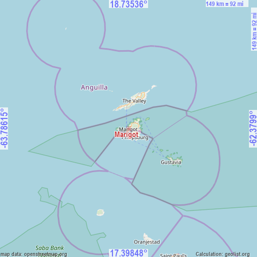
Marigot GPS coordinates[2]
18° 4' 5.484" North, 63° 4' 58.872" West
| Map corner | latitude | longitude |
|---|---|---|
| Upper-left | 18.73536°, | -63.78615° |
| Center: | 18.06819°, | -63.08302° |
| Lower-right: | 17.39848°, | -62.3799° |
| Map W x H: | 148.6×148.6 km | = 92.3×92.3mi |
Elevation
Elevation of Marigot is 9 m = 30 ft, and this is 1.5 m = 5 ft above average elevation for this country.
See also: Saint Martin elevation on elevation.city.
Geographical zone
Marigot is located in North Torrid zone (between Equator and Tropic of Cancer). Distance of this Northern Tropic circle is 596.9 km =370.9 mi to North.| Distance of | km | miles | from Marigot |
|---|---|---|---|
| North Pole | 7998.1 | 4969.8 | to North |
| Arctic Circle | 5392.2 | 3350.6 | to North |
| Tropic Cancer | 596.9 | 370.9 | to North |
| Equator | 2009 | 1248.3 | to South |


7998.1 km
2009 km
 37°
37°Sources, notices
• [Note1] Compared only with cities in Saint Martin existing in our database
• [Src1] Map data: © OpenStreetMap contributors (CC-BY-SA)
• [Src2] Other city data from geonames.org with taken over terms of usage.
• [Src3] Geographical zone / Annual Mean Temperature by Robert A. Rohde @ Wikipedia
