Staro Konjarevo geodata
Staro Konjarevo (Novo Selo) is a populated place; located in North Macedonia in Europe/Skopje (GMT+2) time zone. With population of 887 people, there are 214 cities with bigger population in this country. Compared to other cities in North Macedonia, 69.4% of cities are located further ↑North; 100% of cities are located further ←West and 71% of cities have higher elevation than Staro Konjarevo. Note1


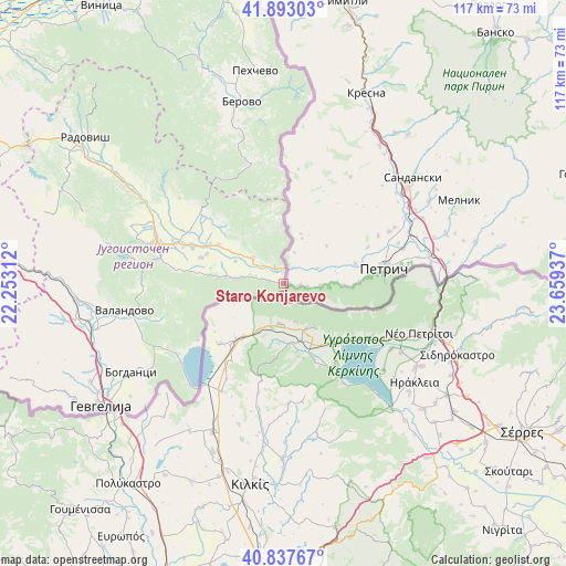
Staro Konjarevo GPS coordinates[2]
41° 22' 2.964" North, 22° 57' 22.464" East
| Map corner | latitude | longitude |
|---|---|---|
| Upper-left | 41.89303°, | 22.25312° |
| Center: | 41.36749°, | 22.95624° |
| Lower-right: | 40.83767°, | 23.65937° |
| Map W x H: | 117.3×117.3 km | = 72.9×72.9mi |
| max Lat: | 42.23276° ⇑69.4% North |
| Staro Konjarevo: | 41.36749° |
| min Lat: | ⇓30.6% South 40.87556° |
| min Long | Staro Konjarevo | max Long |
| 20.52421° | 22.95624° | 22.95624° |
| W 100%⇐ | ⇒0% E |
Elevation
Elevation of Staro Konjarevo is 367 m = 1204 ft, and this is 172.7 m = 567 ft below average elevation for this country.
| Max E: |
1382 m = 4534 ft | 71% |
| Avg. | 539.7 m = 1771 ft | |
| Staro Konjarevo | 367 m = 1204 ft | |
Min E: |
62 m = 203 ft | 29% |
See also: North Macedonia elevation on elevation.city.
Geographical zone
Staro Konjarevo is located in North temperate zone (between Tropic of Cancer and the Arctic Circle). Distance of this Northern Tropic circle is 1993.7 km =1238.8 mi to South.| Distance of | km | miles | from Staro Konjarevo |
|---|---|---|---|
| North Pole | 5407.4 | 3360 | to North |
| Arctic Circle | 2801.5 | 1740.8 | to North |
| Tropic Cancer | 1993.7 | 1238.8 | to South |
| Equator | 4599.6 | 2858.1 | to South |


Nearby cities:
15 places around Staro Konjarevo: (largest is in red/bold)
• Bosilovo
20.7 km =12.9 mi,  293°
293°
• Draževo
3 km =1.9 mi,  282°
282°
• Ilovica
17.2 km =10.7 mi,  312°
312°
• Kuklis
24.6 km =15.3 mi, 279°
• Murtino
19.9 km =12.4 mi, 285°
• Novo Selo
8.2 km =5.1 mi, 310°
• Pirava
35.9 km =22.3 mi,  261°
261°
• Sekirnik
15.7 km =9.8 mi,  300°
300°
• Smolari
4.4 km =2.7 mi, 280°
• Star Dojran
28.2 km =17.5 mi,  224°
224°
• Strumica
27.2 km =16.9 mi, 286°
• Sušica
12.8 km =8 mi, 308°
• Valandovo
33.5 km =20.8 mi, 260°
• Vasilevo
28.7 km =17.8 mi, 294°
• Veljusa
34.6 km =21.5 mi, 290°
Sources, notices
• [Note1] Compared only with cities in North Macedonia existing in our database
• [Src1] Map data: © OpenStreetMap contributors (CC-BY-SA)
• [Src2] Other city data from geonames.org with taken over terms of usage.
• [Src3] Geographical zone / Annual Mean Temperature by Robert A. Rohde @ Wikipedia
