Konče geodata
Konče (Konche) is a seat of a first-order administrative division; located in North Macedonia in Europe/Skopje (GMT+2) time zone. With population of 3,475 people, there are 93 cities with bigger population in this country. Compared to other cities in North Macedonia, 58.9% of cities are located further ↑North; 88.2% of cities are located further ←West and 53.9% of cities have lower elevation than Konče. Note1


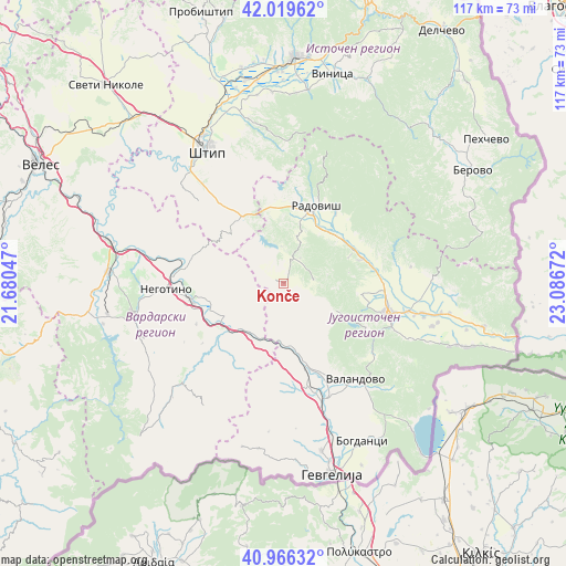
Konče GPS coordinates[2]
41° 29' 42.396" North, 22° 23' 0.924" East
| Map corner | latitude | longitude |
|---|---|---|
| Upper-left | 42.01962°, | 21.68047° |
| Center: | 41.49511°, | 22.38359° |
| Lower-right: | 40.96632°, | 23.08672° |
| Map W x H: | 117.1×117.1 km | = 72.8×72.8mi |
| max Lat: | 42.23276° ⇑58.9% North |
| Konče: | 41.49511° |
| min Lat: | ⇓41.1% South 40.87556° |
| min Long | Konče | max Long |
| 20.52421° | 22.38359° | 22.95624° |
| W 88.2%⇐ | ⇒11.8% E |
Elevation
Elevation of Konče is 580 m = 1903 ft, and this is 40.3 m = 132 ft above average elevation for this country.
| Max E: |
1382 m = 4534 ft | 46.1% |
| Konče | 580 m 1903 ft | |
| Avg. | 539.7 m = 1771 ft | |
Min E: |
62 m = 203 ft | 53.9% |
See also: North Macedonia elevation on elevation.city.
Geographical zone
Konče is located in North temperate zone (between Tropic of Cancer and the Arctic Circle). Distance of this Northern Tropic circle is 2007.9 km =1247.7 mi to South.| Distance of | km | miles | from Konče |
|---|---|---|---|
| North Pole | 5393.2 | 3351.2 | to North |
| Arctic Circle | 2787.4 | 1732 | to North |
| Tropic Cancer | 2007.9 | 1247.7 | to South |
| Equator | 4613.8 | 2866.9 | to South |


Nearby cities:
15 places around Konče: (largest is in red/bold)
• Bosilovo
29.3 km =18.2 mi,  101°
101°
• Demir Kapija
15.1 km =9.4 mi,  229°
229°
• Kuklis
25.5 km =15.8 mi,  113°
113°
• Miravci
21.1 km =13.1 mi,  167°
167°
• Murtino
29.9 km =18.6 mi, 107°
• Negotino
24.4 km =15.2 mi,  267°
267°
• Oraovica
18.1 km =11.2 mi,  36°
36°
• Pirava
23 km =14.3 mi,  147°
147°
• Podareš
18.7 km =11.6 mi, 44°
• Radovis
17.3 km =10.7 mi,  22°
22°
• Strumica
22.6 km =14 mi, 106°
• Valandovo
24.6 km =15.3 mi,  143°
143°
• Vasilevo
21.7 km =13.5 mi, 96°
• Vataša
31.6 km =19.6 mi,  254°
254°
• Veljusa
15.5 km =9.6 mi, 97°
Sources, notices
• [Note1] Compared only with cities in North Macedonia existing in our database
• [Src1] Map data: © OpenStreetMap contributors (CC-BY-SA)
• [Src2] Other city data from geonames.org with taken over terms of usage.
• [Src3] Geographical zone / Annual Mean Temperature by Robert A. Rohde @ Wikipedia
