Kochani geodata
Kochani is a seat of a first-order administrative division; located in North Macedonia in Europe/Skopje (GMT+2) time zone. With population of 34,258 people, there are 17 cities with bigger population in this country. Compared to other cities in North Macedonia, 68% of cities are located further ↓South; 88.6% of cities are located further ←West and 73.1% of cities have higher elevation than Kochani. Note1


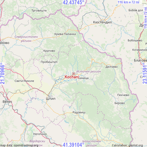
Kochani GPS coordinates[2]
41° 54' 59.004" North, 22° 24' 46.008" East
| Map corner | latitude | longitude |
|---|---|---|
| Upper-left | 42.43745°, | 21.70966° |
| Center: | 41.91639°, | 22.41278° |
| Lower-right: | 41.39104°, | 23.11591° |
| Map W x H: | 116.3×116.3 km | = 72.3×72.3mi |
| max Lat: | 42.23276° ⇑32% North |
| Kochani: | 41.91639° |
| min Lat: | ⇓68% South 40.87556° |
| min Long | Kochani | max Long |
| 20.52421° | 22.41278° | 22.95624° |
| W 88.6%⇐ | ⇒11.4% E |
Elevation
Elevation of Kochani is 354 m = 1161 ft, and this is 185.7 m = 609 ft below average elevation for this country.
| Max E: |
1382 m = 4534 ft | 73.1% |
| Avg. | 539.7 m = 1771 ft | |
| Kochani | 354 m = 1161 ft | |
Min E: |
62 m = 203 ft | 26.9% |
See also: North Macedonia elevation on elevation.city.
Geographical zone
Kochani is located in North temperate zone (between Tropic of Cancer and the Arctic Circle). Distance of this Northern Tropic circle is 2054.7 km =1276.7 mi to South.| Distance of | km | miles | from Kochani |
|---|---|---|---|
| North Pole | 5346.4 | 3322.1 | to North |
| Arctic Circle | 2740.5 | 1702.9 | to North |
| Tropic Cancer | 2054.7 | 1276.7 | to South |
| Equator | 4660.7 | 2896 | to South |


Nearby cities:
15 places around Kochani: (largest is in red/bold)
• Blatec
16.4 km =10.2 mi,  122°
122°
• Delcevo
30 km =18.6 mi,  79°
79°
• Gradec
11 km =6.8 mi,  131°
131°
• Karbinci
18.3 km =11.4 mi,  233°
233°
• Kratovo
26.3 km =16.3 mi,  313°
313°
• Makedonska Kamenica
18.5 km =11.5 mi,  51°
51°
• Oblesevo
7.5 km =4.7 mi,  240°
240°
• Orizari
2.9 km =1.8 mi, 75°
• Probishtip
21.6 km =13.4 mi,  296°
296°
• Shtip
26.1 km =16.2 mi,  223°
223°
• Star Karaorman
22.9 km =14.2 mi, 229°
• Vinica
8.8 km =5.5 mi, 115°
• Zletovo
16.7 km =10.4 mi, 298°
• Zrnovci
7.4 km =4.6 mi,  159°
159°
• Češinovo
11.4 km =7.1 mi, 243°
Sources, notices
• [Note1] Compared only with cities in North Macedonia existing in our database
• [Src1] Map data: © OpenStreetMap contributors (CC-BY-SA)
• [Src2] Other city data from geonames.org with taken over terms of usage.
• [Src3] Geographical zone / Annual Mean Temperature by Robert A. Rohde @ Wikipedia
