Brades geodata
Brades (Saint Peter) is a seat of government of a political entity; located in Montserrat in America/Montserrat (GMT-4) time zone. With population of 1,000 people, there are 0 cities with bigger population in this country. Compared to other cities in Montserrat, 100% of cities are located further ↓South; 80% of cities are located further ←West and 100% of cities have higher elevation than Brades. Note1


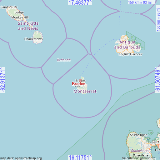
Brades GPS coordinates[2]
16° 47' 30.588" North, 62° 12' 38.088" West
| Map corner | latitude | longitude |
|---|---|---|
| Upper-left | 17.46377°, | -62.91371° |
| Center: | 16.79183°, | -62.21058° |
| Lower-right: | 16.11751°, | -61.50746° |
| Map W x H: | 149.7×149.7 km | = 93×93mi |
| max Lat: | 16.79183° ⇑0% North |
| Brades: | 16.79183° |
| min Lat: | ⇓100% South 16.70555° |
| min Long | Brades | max Long |
| -62.22175° | -62.21058° | -62.19103° |
| W 80%⇐ | ⇒20% E |
Elevation
Elevation of Brades is 52 m = 171 ft, and this is 69.3 m = 227 ft below average elevation for this country.
| Max E: |
214 m = 702 ft | 100% |
| Avg. | 121.3 m = 398 ft | |
| Brades | 52 m = 171 ft | |
Min E: |
52 m = 171 ft | 0% |
See also: Montserrat elevation on elevation.city.
Geographical zone
Brades is located in North Torrid zone (between Equator and Tropic of Cancer). Distance of this Northern Tropic circle is 738.8 km =459.1 mi to North.| Distance of | km | miles | from Brades |
|---|---|---|---|
| North Pole | 8140 | 5058 | to North |
| Arctic Circle | 5534.1 | 3438.7 | to North |
| Tropic Cancer | 738.8 | 459.1 | to North |
| Equator | 1867.1 | 1160.2 | to South |


Nearby cities:
5 places around Brades: (largest is in red/bold)
• Cork Hill
6.8 km =4.2 mi,  184°
184°
• Plymouth
9.6 km =6 mi, 181°
• Saint John's Village
2.3 km =1.4 mi,  117°
117°
• Saint Peters
2.2 km =1.4 mi,  198°
198°
• Salem
4.7 km =2.9 mi,  194°
194°
Sources, notices
• [Note1] Compared only with cities in Montserrat existing in our database
• [Src1] Map data: © OpenStreetMap contributors (CC-BY-SA)
• [Src2] Other city data from geonames.org with taken over terms of usage.
• [Src3] Geographical zone / Annual Mean Temperature by Robert A. Rohde @ Wikipedia
