El Porvenir geodata
El Porvenir (Tabasco) is a populated place; located in Mexico in America/Mexico_City (GMT-6) time zone. With population of 562 people, there are 15183 cities with bigger population in this country. Compared to other cities in Mexico, 77.3% of cities are located further ↑North; 86.1% of cities are located further ←West and 98.1% of cities have higher elevation than El Porvenir. Note1


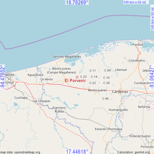
El Porvenir GPS coordinates[2]
18° 6' 56.556" North, 93° 46' 2.604" West
| Map corner | latitude | longitude |
|---|---|---|
| Upper-left | 18.78269°, | -94.47052° |
| Center: | 18.11571°, | -93.76739° |
| Lower-right: | 17.44618°, | -93.06427° |
| Map W x H: | 148.6×148.6 km | = 92.3×92.3mi |
| max Lat: | 32.7° ⇑77.3% North |
| El Porvenir: | 18.11571° |
| min Lat: | ⇓22.7% South 14.53588° |
| min Long | El Porvenir | max Long |
| -117.105° | -93.76739° | -86.73105° |
| W 86.1%⇐ | ⇒13.9% E |
Elevation
Elevation of El Porvenir is 8 m = 26 ft, and this is 1245.7 m = 4087 ft below average elevation for this country.
| Max E: |
3497 m = 11473 ft | 98.1% |
| Avg. | 1253.7 m = 4113 ft | |
| El Porvenir | 8 m = 26 ft | |
Min E: |
-1 m = -3 ft | 1.9% |
See also: Mexico elevation on elevation.city.
Geographical zone
El Porvenir is located in North Torrid zone (between Equator and Tropic of Cancer). Distance of this Northern Tropic circle is 591.6 km =367.6 mi to North.| Distance of | km | miles | from El Porvenir |
|---|---|---|---|
| North Pole | 7992.8 | 4966.5 | to North |
| Arctic Circle | 5386.9 | 3347.3 | to North |
| Tropic Cancer | 591.6 | 367.6 | to North |
| Equator | 2014.3 | 1251.6 | to South |


Nearby cities:
15 places around El Porvenir: (largest is in red/bold)
• Azucena 3ra. Sección (El Triunfo)
20.4 km =12.7 mi,  25°
25°
• Azucenita 1ra. Sección B
21.3 km =13.2 mi,  42°
42°
• Benito Juárez 1ra. Sección
12.4 km =7.7 mi,  251°
251°
• Blasillo 1ra. Sección (Nicolás Bravo)
16.5 km =10.3 mi,  255°
255°
• Blasillo 2da. Sección (Otates)
19.3 km =12 mi, 253°
• Huapacal 1ra. Sección
21 km =13 mi,  179°
179°
• La Vencedora
10.6 km =6.6 mi,  226°
226°
• Palo Mulato
10.6 km =6.6 mi, 181°
• Paso de la Mina 2da. Sección (Barrial)
19.8 km =12.3 mi,  155°
155°
• Paso de la Mina 3ra. Sección
20.1 km =12.5 mi,  147°
147°
• Pejelagartero 1ra. Sección (El Arroyito)
10 km =6.2 mi,  190°
190°
• Pejelagartero 1ra. Sección (Plataforma)
9.1 km =5.7 mi,  221°
221°
• Poblado C-11 José María Morelos y Pavón
16.5 km =10.3 mi,  66°
66°
• Zanapa 1ra. Sección
19.5 km =12.1 mi,  204°
204°
• Zapotal 5ta. Sección
11 km =6.8 mi,  171°
171°
Sources, notices
• [Note1] Compared only with cities in Mexico existing in our database
• [Src1] Map data: © OpenStreetMap contributors (CC-BY-SA)
• [Src2] Other city data from geonames.org with taken over terms of usage.
• [Src3] Geographical zone / Annual Mean Temperature by Robert A. Rohde @ Wikipedia
