Huapacal 2da. Sección geodata
Huapacal 2da. Sección (Tabasco) is a populated place; located in Mexico in America/Mexico_City (GMT-6) time zone. With population of 844 people, there are 10365 cities with bigger population in this country. Compared to other cities in Mexico, 79.7% of cities are located further ↑North; 86.1% of cities are located further ←West and 90.8% of cities have higher elevation than Huapacal 2da. Sección. Note1
Current local time in Huapacal 2da. Sección:
06:34 AM, WednesdayDifference from your time zone: hours


Huapacal 2da. Sección GPS coordinates[2]
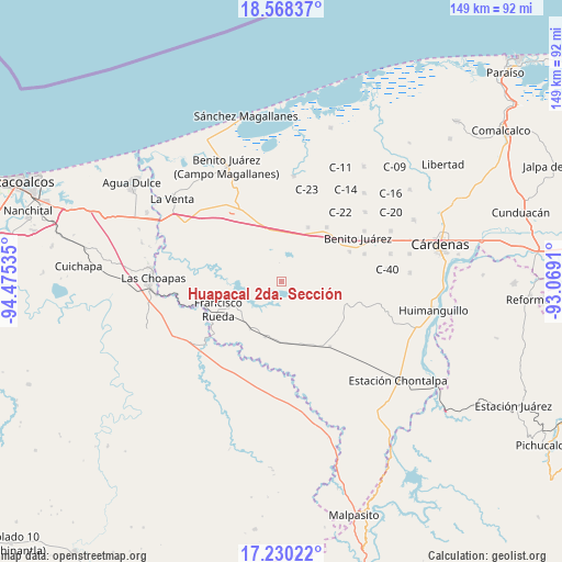
17° 54' 2.016" North, 93° 46' 19.992" West
| Map corner | latitude | longitude |
|---|---|---|
| Upper-left | 18.56837°, | -94.47535° |
| Center: | 17.90056°, | -93.77222° |
| Lower-right: | 17.23022°, | -93.0691° |
| Map W x H: | 148.8×148.8 km | = 92.5×92.5mi |
| max Lat: | 32.7° ⇑79.7% North |
| Huapacal 2da. Sección: | 17.90056° |
| min Lat: | ⇓20.3% South 14.53588° |
| min Long | Huapacal 2da. S | max Long |
| -117.105° | -93.77222° | -86.73105° |
| W 86.1%⇐ | ⇒13.9% E |
Elevation
Elevation of Huapacal 2da. Sección is 22 m = 72 ft, and this is 1231.7 m = 4041 ft below average elevation for this country.
| Max E: |
3497 m = 11473 ft | 90.8% |
| Avg. | 1253.7 m = 4113 ft | |
| Huapacal 2da. Sección | 22 m = 72 ft | |
Min E: |
-1 m = -3 ft | 9.2% |
See also: Mexico elevation on elevation.city.
Geographical zone
Huapacal 2da. Sección is located in North Torrid zone (between Equator and Tropic of Cancer). Distance of this Northern Tropic circle is 615.6 km =382.5 mi to North.| Distance of | km | miles | from Huapacal 2da. Sección |
|---|---|---|---|
| North Pole | 8016.7 | 4981.3 | to North |
| Arctic Circle | 5410.8 | 3362.1 | to North |
| Tropic Cancer | 615.6 | 382.5 | to North |
| Equator | 1990.4 | 1236.8 | to South |


Nearby cities:
15 places around Huapacal 2da. Sección: (largest is in red/bold)
• Francisco Martínez Gaytán
15.2 km =9.4 mi,  196°
196°
• Francisco Rueda
18.9 km =11.7 mi,  245°
245°
• Huapacal 1ra. Sección
3 km =1.9 mi,  11°
11°
• La Vencedora
18.1 km =11.2 mi,  336°
336°
• Manuel Sánchez Mármol
16.8 km =10.4 mi,  162°
162°
• Palo Mulato
13.3 km =8.3 mi,  1°
1°
• Paso de la Mina 1ra. Sección
4.4 km =2.7 mi,  60°
60°
• Paso de la Mina 2da. Sección (Barrial)
10.4 km =6.5 mi, 56°
• Paso de la Mina 3ra. Sección
13.2 km =8.2 mi, 58°
• Pejelagartero 1ra. Sección (El Arroyito)
14.2 km =8.8 mi,  354°
354°
• Pejelagartero 1ra. Sección (Plataforma)
18 km =11.2 mi, 342°
• Tierra Colorada 1ra. Sección
9.2 km =5.7 mi,  96°
96°
• Tres Bocas 1ra. Sección
11.4 km =7.1 mi,  288°
288°
• Zanapa 1ra. Sección
9.9 km =6.2 mi,  309°
309°
• Zapotal 5ta. Sección
13.2 km =8.2 mi, 9°
Sources, notices
• [Note1] Compared only with cities in Mexico existing in our database
• [Src1] Map data: © OpenStreetMap contributors (CC-BY-SA)
• [Src2] Other city data from geonames.org with taken over terms of usage.
• [Src3] Geographical zone / Annual Mean Temperature by Robert A. Rohde @ Wikipedia
