Nuevo Centro de Población Agrícola el Chacón geodata
Nuevo Centro de Población Agrícola el Chacón (Hidalgo) is a populated place; located in Mexico in America/Mexico_City (GMT-6) time zone. With population of 1,655 people, there are 5245 cities with bigger population in this country. Compared to other cities in Mexico, 58.6% of cities are located further ↓South; 54.5% of cities are located further ←West and 88.7% of cities have lower elevation than Nuevo Centro de Población Agrícola el Chacón. Note1
Current local time in Nuevo Centro de Población Agrícola el Chacón:
06:53 AM, WednesdayDifference from your time zone: hours


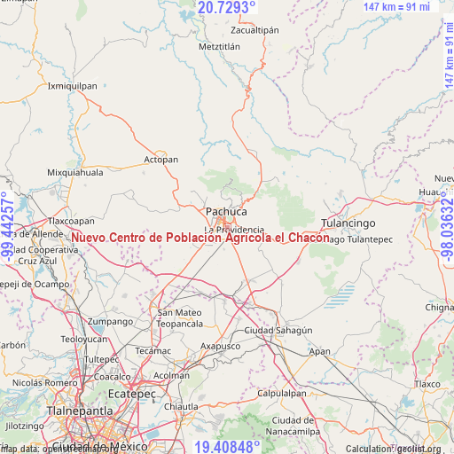
Nuevo Centro de Población Agrícola el Chacón GPS coordinates[2]
20° 4' 13.008" North, 98° 44' 21.984" West
| Map corner | latitude | longitude |
|---|---|---|
| Upper-left | 20.7293°, | -99.44257° |
| Center: | 20.07028°, | -98.73944° |
| Lower-right: | 19.40848°, | -98.03632° |
| Map W x H: | 146.9×146.9 km | = 91.3×91.3mi |
| max Lat: | 32.7° ⇑41.4% North |
| Nuevo Centro de Población Agrícola el Chacón: | 20.07028° |
| min Lat: | ⇓58.6% South 14.53588° |
| min Long | Nuevo Centro de | max Long |
| -117.105° | -98.73944° | -86.73105° |
| W 54.5%⇐ | ⇒45.5% E |
Elevation
Elevation of Nuevo Centro de Población Agrícola el Chacón is 2364 m = 7756 ft, and this is 1110.3 m = 3643 ft above average elevation for this country.
| Max E: |
3497 m = 11473 ft | 11.3% |
| Nuevo Centro de Población Agrícola el Chacón | 2364 m 7756 ft | |
| Avg. | 1253.7 m = 4113 ft | |
Min E: |
-1 m = -3 ft | 88.7% |
See also: Mexico elevation on elevation.city.
Geographical zone
Nuevo Centro de Población Agrícola el Chacón is located in North Torrid zone (between Equator and Tropic of Cancer). Distance of this Northern Tropic circle is 374.3 km =232.6 mi to North.| Distance of | km | miles | from Nuevo Centro de Población Agrícola el Chacón |
|---|---|---|---|
| North Pole | 7775.5 | 4831.5 | to North |
| Arctic Circle | 5169.6 | 3212.2 | to North |
| Tropic Cancer | 374.3 | 232.6 | to North |
| Equator | 2231.6 | 1386.7 | to South |


Nearby cities:
15 places around Nuevo Centro de Población Agrícola el Chacón: (largest is in red/bold)
• Colinas de Plata
1.6 km =1 mi,  56°
56°
• El Paraíso
1 km =0.6 mi,  193°
193°
• El Roble
2.4 km =1.5 mi,  235°
235°
• El Saucillo
0.8 km =0.5 mi,  17°
17°
• El Saucillo (Fraccionamiento)
0.8 km =0.5 mi,  109°
109°
• El Venado
2.3 km =1.4 mi,  249°
249°
• Forjadores de Pachuca
3 km =1.9 mi, 235°
• La Providencia Siglo XXI
2.4 km =1.5 mi, 106°
• Los Tuzos
2.5 km =1.6 mi,  224°
224°
• PRI Chacón
1.3 km =0.8 mi,  11°
11°
• Rinconadas de San Francisco
3 km =1.9 mi,  261°
261°
• Rinconadas del Venado I
2.6 km =1.6 mi, 253°
• San Cristóbal Chacón
1.3 km =0.8 mi,  32°
32°
• Tulipanes
3.1 km =1.9 mi, 249°
• Unidad Habitacional Dina-Sidena Chacón
1.5 km =0.9 mi,  2°
2°
Sources, notices
• [Note1] Compared only with cities in Mexico existing in our database
• [Src1] Map data: © OpenStreetMap contributors (CC-BY-SA)
• [Src2] Other city data from geonames.org with taken over terms of usage.
• [Src3] Geographical zone / Annual Mean Temperature by Robert A. Rohde @ Wikipedia
