Laguneta geodata
Laguneta (Veracruz) is a populated place; located in Mexico in America/Mexico_City (GMT-6) time zone. With population of 1,139 people, there are 7626 cities with bigger population in this country. Compared to other cities in Mexico, 74.4% of cities are located further ↑North; 84.1% of cities are located further ←West and 69% of cities have higher elevation than Laguneta. Note1


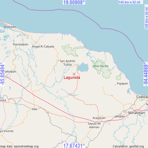
Laguneta GPS coordinates[2]
18° 20' 34.728" North, 95° 9' 6.516" West
| Map corner | latitude | longitude |
|---|---|---|
| Upper-left | 19.00908°, | -95.85494° |
| Center: | 18.34298°, | -95.15181° |
| Lower-right: | 17.67431°, | -94.44869° |
| Map W x H: | 148.4×148.4 km | = 92.2×92.2mi |
| max Lat: | 32.7° ⇑74.4% North |
| Laguneta: | 18.34298° |
| min Lat: | ⇓25.6% South 14.53588° |
| min Long | Laguneta | max Long |
| -117.105° | -95.15181° | -86.73105° |
| W 84.1%⇐ | ⇒15.9% E |
Elevation
Elevation of Laguneta is 471 m = 1545 ft, and this is 782.7 m = 2568 ft below average elevation for this country.
| Max E: |
3497 m = 11473 ft | 69% |
| Avg. | 1253.7 m = 4113 ft | |
| Laguneta | 471 m = 1545 ft | |
Min E: |
-1 m = -3 ft | 31% |
See also: Mexico elevation on elevation.city.
Geographical zone
Laguneta is located in North Torrid zone (between Equator and Tropic of Cancer). Distance of this Northern Tropic circle is 566.4 km =351.9 mi to North.| Distance of | km | miles | from Laguneta |
|---|---|---|---|
| North Pole | 7967.5 | 4950.8 | to North |
| Arctic Circle | 5361.6 | 3331.5 | to North |
| Tropic Cancer | 566.4 | 351.9 | to North |
| Equator | 2039.5 | 1267.3 | to South |


Nearby cities:
15 places around Laguneta: (largest is in red/bold)
• Bezuapan
7.4 km =4.6 mi,  355°
355°
• Cebadilla Chica
3.9 km =2.4 mi,  317°
317°
• Chuniapan de Abajo
7.6 km =4.7 mi,  283°
283°
• Chuniapan de Arriba
3.2 km =2 mi, 280°
• Comoapan
7.5 km =4.7 mi,  341°
341°
• Cuesta Amarilla
8.7 km =5.4 mi,  272°
272°
• El Huidero
5.7 km =3.5 mi,  329°
329°
• El Salto de Eyipantla
7.5 km =4.7 mi,  313°
313°
• La Candelaria
2.7 km =1.7 mi,  124°
124°
• La Victoria
4.7 km =2.9 mi,  41°
41°
• Maxacapan
6 km =3.7 mi,  29°
29°
• Pozolapan (Cartagena)
6.5 km =4 mi,  70°
70°
• San Juan Seco de Valencia
3.8 km =2.4 mi,  186°
186°
• Tulapam
8.5 km =5.3 mi,  247°
247°
• Zapoapan de Cabañas
5.8 km =3.6 mi,  99°
99°
Sources, notices
• [Note1] Compared only with cities in Mexico existing in our database
• [Src1] Map data: © OpenStreetMap contributors (CC-BY-SA)
• [Src2] Other city data from geonames.org with taken over terms of usage.
• [Src3] Geographical zone / Annual Mean Temperature by Robert A. Rohde @ Wikipedia
