La Arrocera geodata
La Arrocera (Sinaloa) is a populated place; located in Mexico in America/Mazatlan (GMT-7) time zone. With population of 712 people, there are 12235 cities with bigger population in this country. Compared to other cities in Mexico, 94.4% of cities are located further ↓South; 96.8% of cities are located further →East and 87.7% of cities have higher elevation than La Arrocera. Note1


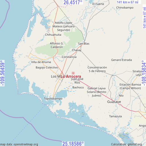
La Arrocera GPS coordinates[2]
25° 49' 13.692" North, 108° 51' 41.256" West
| Map corner | latitude | longitude |
|---|---|---|
| Upper-left | 26.4517°, | -109.56459° |
| Center: | 25.82047°, | -108.86146° |
| Lower-right: | 25.18586°, | -108.15834° |
| Map W x H: | 140.7×140.7 km | = 87.4×87.4mi |
| max Lat: | 32.7° ⇑5.6% North |
| La Arrocera: | 25.82047° |
| min Lat: | ⇓94.4% South 14.53588° |
| min Long | La Arrocera | max Long |
| -117.105° | -108.86146° | -86.73105° |
| W 3.2%⇐ | ⇒96.8% E |
Elevation
Elevation of La Arrocera is 31 m = 102 ft, and this is 1222.7 m = 4011 ft below average elevation for this country.
| Max E: |
3497 m = 11473 ft | 87.7% |
| Avg. | 1253.7 m = 4113 ft | |
| La Arrocera | 31 m = 102 ft | |
Min E: |
-1 m = -3 ft | 12.3% |
See also: Mexico elevation on elevation.city.
Geographical zone
La Arrocera is located in North temperate zone (between Tropic of Cancer and the Arctic Circle). Distance of this Northern Tropic circle is 265 km =164.7 mi to South.| Distance of | km | miles | from La Arrocera |
|---|---|---|---|
| North Pole | 7136.1 | 4434.2 | to North |
| Arctic Circle | 4530.2 | 2814.9 | to North |
| Tropic Cancer | 265 | 164.7 | to South |
| Equator | 2871 | 1784 | to South |


Nearby cities:
15 places around La Arrocera: (largest is in red/bold)
• Campo la Arrocera
6.3 km =3.9 mi,  295°
295°
• Cerrillos (Campo 35)
7.5 km =4.7 mi,  328°
328°
• Cuatro Milpas
8.3 km =5.2 mi,  339°
339°
• Dos de Abril
12.8 km =8 mi,  321°
321°
• Ejido Antonio Rosales
12.3 km =7.6 mi, 317°
• Ejido Cinco de Mayo
10.3 km =6.4 mi,  288°
288°
• El Uno
6.5 km =4 mi,  311°
311°
• Héroes Mexicanos
12.6 km =7.8 mi,  117°
117°
• Juan José Ríos
7.9 km =4.9 mi,  151°
151°
• Kilómetro 19
12.1 km =7.5 mi,  5°
5°
• Kilómetro 26 (Las Panguitas)
9.5 km =5.9 mi,  41°
41°
• La Genoveva
7 km =4.3 mi, 312°
• Primero de Mayo
11.6 km =7.2 mi,  219°
219°
• Pueblo Nuevo Luis Echeverría
0.9 km =0.6 mi,  181°
181°
• Taxtes
13 km =8.1 mi, 325°
Sources, notices
• [Note1] Compared only with cities in Mexico existing in our database
• [Src1] Map data: © OpenStreetMap contributors (CC-BY-SA)
• [Src2] Other city data from geonames.org with taken over terms of usage.
• [Src3] Geographical zone / Annual Mean Temperature by Robert A. Rohde @ Wikipedia
