Plan de Ayala geodata
Plan de Ayala (Durango) is a populated place; located in Mexico in America/Monterrey (GMT-6) time zone. With population of 899 people, there are 9699 cities with bigger population in this country. Compared to other cities in Mexico, 89.7% of cities are located further ↓South; 91.1% of cities are located further →East and 68.2% of cities have lower elevation than Plan de Ayala. Note1


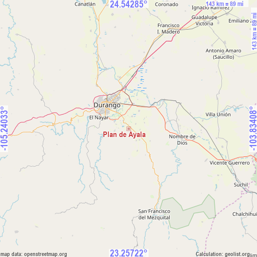
Plan de Ayala GPS coordinates[2]
23° 54' 5.868" North, 104° 32' 13.92" West
| Map corner | latitude | longitude |
|---|---|---|
| Upper-left | 24.54285°, | -105.24033° |
| Center: | 23.90163°, | -104.5372° |
| Lower-right: | 23.25722°, | -103.83408° |
| Map W x H: | 142.9×143 km | = 88.8×88.9mi |
| max Lat: | 32.7° ⇑10.3% North |
| Plan de Ayala: | 23.90163° |
| min Lat: | ⇓89.7% South 14.53588° |
| min Long | Plan de Ayala | max Long |
| -117.105° | -104.5372° | -86.73105° |
| W 8.9%⇐ | ⇒91.1% E |
Elevation
Elevation of Plan de Ayala is 1893 m = 6211 ft, and this is 639.3 m = 2097 ft above average elevation for this country.
| Max E: |
3497 m = 11473 ft | 31.8% |
| Plan de Ayala | 1893 m 6211 ft | |
| Avg. | 1253.7 m = 4113 ft | |
Min E: |
-1 m = -3 ft | 68.2% |
See also: Mexico elevation on elevation.city.
Geographical zone
Plan de Ayala is located in North temperate zone (between Tropic of Cancer and the Arctic Circle). Distance of this Northern Tropic circle is 51.7 km =32.1 mi to South.| Distance of | km | miles | from Plan de Ayala |
|---|---|---|---|
| North Pole | 7349.4 | 4566.7 | to North |
| Arctic Circle | 4743.6 | 2947.5 | to North |
| Tropic Cancer | 51.7 | 32.1 | to South |
| Equator | 2657.6 | 1651.4 | to South |


Nearby cities:
15 places around Plan de Ayala: (largest is in red/bold)
• Aquiles Serdán
6.5 km =4 mi,  314°
314°
• Dolores Hidalgo
11.7 km =7.3 mi,  341°
341°
• Gabino Santillán
10.6 km =6.6 mi,  326°
326°
• Ignacio López Rayón
4.8 km =3 mi,  55°
55°
• José María Pino Suárez
5.4 km =3.4 mi,  119°
119°
• José Refugio Salcido
7.2 km =4.5 mi,  15°
15°
• Parras de la Fuente
10.7 km =6.6 mi,  3°
3°
• Pilar de Zaragoza
7.3 km =4.5 mi,  290°
290°
• Praxedis G. Guerrero Nuevo (La Loma)
5.2 km =3.2 mi, 326°
• Río Escondido (La Loma)
8.2 km =5.1 mi,  258°
258°
• Santiago Bayacora
7.7 km =4.8 mi, 263°
• Sebastián Lerdo de Tejada
11.7 km =7.3 mi,  300°
300°
• Tomás Urbina
8.6 km =5.3 mi,  135°
135°
• Valle Florido
7.8 km =4.8 mi,  147°
147°
• Villa Montemorelos
11.5 km =7.1 mi,  29°
29°
Sources, notices
• [Note1] Compared only with cities in Mexico existing in our database
• [Src1] Map data: © OpenStreetMap contributors (CC-BY-SA)
• [Src2] Other city data from geonames.org with taken over terms of usage.
• [Src3] Geographical zone / Annual Mean Temperature by Robert A. Rohde @ Wikipedia
