Luchanas geodata
Luchanas (Coahuila) is a populated place; located in Mexico in America/Monterrey (GMT-6) time zone. With population of 2,929 people, there are 3043 cities with bigger population in this country. Compared to other cities in Mexico, 94.2% of cities are located further ↓South; 86.5% of cities are located further →East and 57.7% of cities have higher elevation than Luchanas. Note1


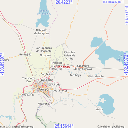
Luchanas GPS coordinates[2]
25° 47' 27.276" North, 103° 11' 37.824" West
| Map corner | latitude | longitude |
|---|---|---|
| Upper-left | 26.4223°, | -103.89697° |
| Center: | 25.79091°, | -103.19384° |
| Lower-right: | 25.15614°, | -102.49072° |
| Map W x H: | 140.8×140.8 km | = 87.5×87.5mi |
| max Lat: | 32.7° ⇑5.8% North |
| Luchanas: | 25.79091° |
| min Lat: | ⇓94.2% South 14.53588° |
| min Long | Luchanas | max Long |
| -117.105° | -103.19384° | -86.73105° |
| W 13.5%⇐ | ⇒86.5% E |
Elevation
Elevation of Luchanas is 1110 m = 3642 ft, and this is 143.7 m = 471 ft below average elevation for this country.
| Max E: |
3497 m = 11473 ft | 57.7% |
| Avg. | 1253.7 m = 4113 ft | |
| Luchanas | 1110 m = 3642 ft | |
Min E: |
-1 m = -3 ft | 42.3% |
See also: Mexico elevation on elevation.city.
Geographical zone
Luchanas is located in North temperate zone (between Tropic of Cancer and the Arctic Circle). Distance of this Northern Tropic circle is 261.8 km =162.7 mi to South.| Distance of | km | miles | from Luchanas |
|---|---|---|---|
| North Pole | 7139.4 | 4436.2 | to North |
| Arctic Circle | 4533.5 | 2817 | to North |
| Tropic Cancer | 261.8 | 162.7 | to South |
| Equator | 2867.7 | 1781.9 | to South |


Nearby cities:
15 places around Luchanas: (largest is in red/bold)
• Alejo González (Bilbao)
3.5 km =2.2 mi,  358°
358°
• Concordia
7.8 km =4.8 mi,  99°
99°
• El Retiro
7.6 km =4.7 mi,  57°
57°
• Emiliano Zapata (Albia)
7.3 km =4.5 mi,  13°
13°
• Francisco I. Madero
8 km =5 mi,  255°
255°
• Guadalupe Victoria
5.6 km =3.5 mi,  214°
214°
• La Fe
6.3 km =3.9 mi,  353°
353°
• La Victoria
8.3 km =5.2 mi, 11°
• Primero de Mayo
4 km =2.5 mi,  40°
40°
• San Francisco de Arriba
5.9 km =3.7 mi,  140°
140°
• San Lorenzo
8.6 km =5.3 mi,  151°
151°
• Santa Mónica
6 km =3.7 mi,  184°
184°
• Seis de Octubre (Santo Niño)
5.4 km =3.4 mi,  236°
236°
• Veinte de Noviembre (Santa Lucía)
4.3 km =2.7 mi,  92°
92°
• Virginias
7.9 km =4.9 mi,  277°
277°
Sources, notices
• [Note1] Compared only with cities in Mexico existing in our database
• [Src1] Map data: © OpenStreetMap contributors (CC-BY-SA)
• [Src2] Other city data from geonames.org with taken over terms of usage.
• [Src3] Geographical zone / Annual Mean Temperature by Robert A. Rohde @ Wikipedia
