La Aldea geodata
La Aldea (Guanajuato) is a populated place; located in Mexico in America/Mexico_City (GMT-6) time zone. With population of 5,615 people, there are 1660 cities with bigger population in this country. Compared to other cities in Mexico, 74.9% of cities are located further ↓South; 77.2% of cities are located further →East and 62% of cities have lower elevation than La Aldea. Note1


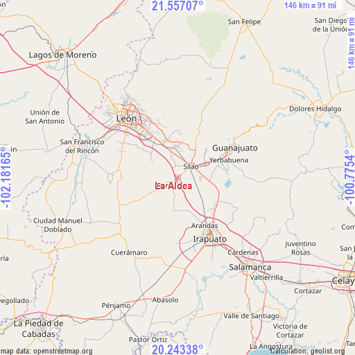
La Aldea GPS coordinates[2]
20° 54' 5.976" North, 101° 28' 42.672" West
| Map corner | latitude | longitude |
|---|---|---|
| Upper-left | 21.55707°, | -102.18165° |
| Center: | 20.90166°, | -101.47852° |
| Lower-right: | 20.24338°, | -100.7754° |
| Map W x H: | 146.1×146.1 km | = 90.8×90.8mi |
| max Lat: | 32.7° ⇑25.1% North |
| La Aldea: | 20.90166° |
| min Lat: | ⇓74.9% South 14.53588° |
| min Long | La Aldea | max Long |
| -117.105° | -101.47852° | -86.73105° |
| W 22.8%⇐ | ⇒77.2% E |
Elevation
Elevation of La Aldea is 1760 m = 5774 ft, and this is 506.3 m = 1661 ft above average elevation for this country.
| Max E: |
3497 m = 11473 ft | 38% |
| La Aldea | 1760 m 5774 ft | |
| Avg. | 1253.7 m = 4113 ft | |
Min E: |
-1 m = -3 ft | 62% |
See also: Mexico elevation on elevation.city.
Geographical zone
La Aldea is located in North Torrid zone (between Equator and Tropic of Cancer). Distance of this Northern Tropic circle is 281.9 km =175.2 mi to North.| Distance of | km | miles | from La Aldea |
|---|---|---|---|
| North Pole | 7683 | 4774 | to North |
| Arctic Circle | 5077.1 | 3154.8 | to North |
| Tropic Cancer | 281.9 | 175.2 | to North |
| Equator | 2324 | 1444.1 | to South |


Nearby cities:
15 places around La Aldea: (largest is in red/bold)
• Bajío de Bonillas
5.6 km =3.5 mi,  341°
341°
• Colonia Rafael Corrales Ayala
3.9 km =2.4 mi,  270°
270°
• El Escoplo
3.5 km =2.2 mi,  285°
285°
• El Nuevo Condado
4.9 km =3 mi,  48°
48°
• Franco
4.9 km =3 mi,  20°
20°
• Guadalupe de Ramales
2.9 km =1.8 mi,  346°
346°
• La Soledad
6.9 km =4.3 mi,  85°
85°
• Los Medranos
4.9 km =3 mi,  115°
115°
• Lucero de Ramales
3.3 km =2.1 mi,  42°
42°
• Maravillas de las Victorias
5.5 km =3.4 mi,  170°
170°
• Romita
5.2 km =3.2 mi,  229°
229°
• San Francisco Puerta Grande
2.9 km =1.8 mi,  190°
190°
• San Isidro del Arenal
4.2 km =2.6 mi, 85°
• San José de Gracia
3.3 km =2.1 mi,  96°
96°
• Silao
7.1 km =4.4 mi, 48°
Sources, notices
• [Note1] Compared only with cities in Mexico existing in our database
• [Src1] Map data: © OpenStreetMap contributors (CC-BY-SA)
• [Src2] Other city data from geonames.org with taken over terms of usage.
• [Src3] Geographical zone / Annual Mean Temperature by Robert A. Rohde @ Wikipedia
