Jofre geodata
Jofre (Guanajuato) is a populated place; located in Mexico in America/Mexico_City (GMT-6) time zone. With population of 647 people, there are 13375 cities with bigger population in this country. Compared to other cities in Mexico, 67.1% of cities are located further ↓South; 72.2% of cities are located further →East and 62.2% of cities have lower elevation than Jofre. Note1


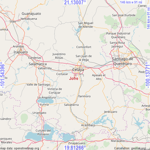
Jofre GPS coordinates[2]
20° 28' 22.008" North, 100° 50' 26.988" West
| Map corner | latitude | longitude |
|---|---|---|
| Upper-left | 21.13007°, | -101.54396° |
| Center: | 20.47278°, | -100.84083° |
| Lower-right: | 19.81266°, | -100.13771° |
| Map W x H: | 146.5×146.5 km | = 91×91mi |
| max Lat: | 32.7° ⇑32.9% North |
| Jofre: | 20.47278° |
| min Lat: | ⇓67.1% South 14.53588° |
| min Long | Jofre | max Long |
| -117.105° | -100.84083° | -86.73105° |
| W 27.8%⇐ | ⇒72.2% E |
Elevation
Elevation of Jofre is 1763 m = 5784 ft, and this is 509.3 m = 1671 ft above average elevation for this country.
| Max E: |
3497 m = 11473 ft | 37.8% |
| Jofre | 1763 m 5784 ft | |
| Avg. | 1253.7 m = 4113 ft | |
Min E: |
-1 m = -3 ft | 62.2% |
See also: Mexico elevation on elevation.city.
Geographical zone
Jofre is located in North Torrid zone (between Equator and Tropic of Cancer). Distance of this Northern Tropic circle is 329.6 km =204.8 mi to North.| Distance of | km | miles | from Jofre |
|---|---|---|---|
| North Pole | 7730.7 | 4803.6 | to North |
| Arctic Circle | 5124.8 | 3184.4 | to North |
| Tropic Cancer | 329.6 | 204.8 | to North |
| Equator | 2276.4 | 1414.5 | to South |


Nearby cities:
15 places around Jofre: (largest is in red/bold)
• Arreguín de Arriba
6.4 km =4 mi,  175°
175°
• Celaya
6.2 km =3.9 mi,  24°
24°
• Colonia Patria Nueva
7.4 km =4.6 mi,  326°
326°
• Colonia Pedro María Anaya
7.1 km =4.4 mi, 327°
• El Puesto
1.4 km =0.9 mi,  107°
107°
• Estrada
6.8 km =4.2 mi,  337°
337°
• La Cruz
5 km =3.1 mi, 110°
• La Palmita (La Palmita de San Gabriel)
4.8 km =3 mi,  305°
305°
• Los Mancera
3.9 km =2.4 mi,  94°
94°
• Merino
5.1 km =3.2 mi,  297°
297°
• Michinelas
3.3 km =2.1 mi,  78°
78°
• Primera Fracción de Crespo
2.8 km =1.7 mi, 337°
• Santa Anita
2.7 km =1.7 mi,  95°
95°
• Santa Fe de la Purísima
6 km =3.7 mi, 295°
• Santa María del Refugio
5.6 km =3.5 mi,  130°
130°
Sources, notices
• [Note1] Compared only with cities in Mexico existing in our database
• [Src1] Map data: © OpenStreetMap contributors (CC-BY-SA)
• [Src2] Other city data from geonames.org with taken over terms of usage.
• [Src3] Geographical zone / Annual Mean Temperature by Robert A. Rohde @ Wikipedia
