Guadalupe Trujillo geodata
Guadalupe Trujillo (Zacatecas) is a populated place; located in Mexico in America/Mexico_City (GMT-6) time zone. With population of 573 people, there are 14945 cities with bigger population in this country. Compared to other cities in Mexico, 88.1% of cities are located further ↓South; 86.6% of cities are located further →East and 80.1% of cities have lower elevation than Guadalupe Trujillo. Note1


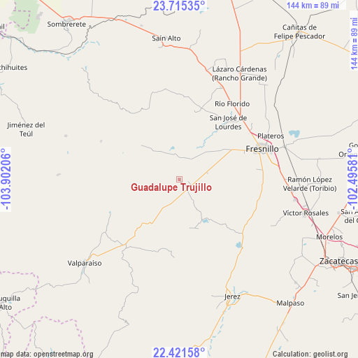
Guadalupe Trujillo GPS coordinates[2]
23° 4' 12.072" North, 103° 11' 56.148" West
| Map corner | latitude | longitude |
|---|---|---|
| Upper-left | 23.71535°, | -103.90206° |
| Center: | 23.07002°, | -103.19893° |
| Lower-right: | 22.42158°, | -102.49581° |
| Map W x H: | 143.9×143.9 km | = 89.4×89.4mi |
| max Lat: | 32.7° ⇑11.9% North |
| Guadalupe Trujillo: | 23.07002° |
| min Lat: | ⇓88.1% South 14.53588° |
| min Long | Guadalupe Truji | max Long |
| -117.105° | -103.19893° | -86.73105° |
| W 13.4%⇐ | ⇒86.6% E |
Elevation
Elevation of Guadalupe Trujillo is 2143 m = 7031 ft, and this is 889.3 m = 2918 ft above average elevation for this country.
| Max E: |
3497 m = 11473 ft | 19.9% |
| Guadalupe Trujillo | 2143 m 7031 ft | |
| Avg. | 1253.7 m = 4113 ft | |
Min E: |
-1 m = -3 ft | 80.1% |
See also: Mexico elevation on elevation.city.
Geographical zone
Guadalupe Trujillo is located in North Torrid zone (between Equator and Tropic of Cancer). Distance of this Northern Tropic circle is 40.8 km =25.4 mi to North.| Distance of | km | miles | from Guadalupe Trujillo |
|---|---|---|---|
| North Pole | 7441.9 | 4624.2 | to North |
| Arctic Circle | 4836 | 3005 | to North |
| Tropic Cancer | 40.8 | 25.4 | to North |
| Equator | 2565.1 | 1593.9 | to South |


Nearby cities:
15 places around Guadalupe Trujillo: (largest is in red/bold)
• Buenavista de Trujillo
9.2 km =5.7 mi,  7°
7°
• Carrillo
26.3 km =16.3 mi,  55°
55°
• Colonia Plenitud
22.1 km =13.7 mi,  35°
35°
• El Salto
19.4 km =12.1 mi, 43°
• Ermita de los Correas
26.1 km =16.2 mi,  134°
134°
• Labor de Santa Barbara
6.2 km =3.9 mi,  185°
185°
• Matías Ramos
2.8 km =1.7 mi,  33°
33°
• Melchor Ocampo (San Jerónimo)
9.4 km =5.8 mi, 27°
• México Nuevo Uno (México Nuevo)
22.5 km =14 mi, 56°
• San Cristóbal
18.8 km =11.7 mi,  51°
51°
• San José del Alamito
18 km =11.2 mi, 63°
• San José del Río
16.5 km =10.3 mi,  333°
333°
• Santa Rosa
18.1 km =11.2 mi,  150°
150°
• Tapias de Santa Cruz (Pedro Ruiz González)
14.9 km =9.3 mi, 27°
• Trujillo
10.2 km =6.3 mi, 11°
Sources, notices
• [Note1] Compared only with cities in Mexico existing in our database
• [Src1] Map data: © OpenStreetMap contributors (CC-BY-SA)
• [Src2] Other city data from geonames.org with taken over terms of usage.
• [Src3] Geographical zone / Annual Mean Temperature by Robert A. Rohde @ Wikipedia
