Baburia geodata
Baburia (Sinaloa) is a populated place; located in Mexico in America/Mazatlan (GMT-7) time zone. With population of 1,477 people, there are 5846 cities with bigger population in this country. Compared to other cities in Mexico, 94.6% of cities are located further ↓South; 95.8% of cities are located further →East and 83% of cities have higher elevation than Baburia. Note1


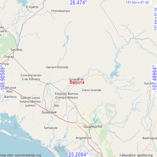
Baburia GPS coordinates[2]
25° 50' 34.404" North, 108° 12' 9.936" West
| Map corner | latitude | longitude |
|---|---|---|
| Upper-left | 26.474°, | -108.90589° |
| Center: | 25.84289°, | -108.20276° |
| Lower-right: | 25.2084°, | -107.49964° |
| Map W x H: | 140.7×140.7 km | = 87.4×87.4mi |
| max Lat: | 32.7° ⇑5.4% North |
| Baburia: | 25.84289° |
| min Lat: | ⇓94.6% South 14.53588° |
| min Long | Baburia | max Long |
| -117.105° | -108.20276° | -86.73105° |
| W 4.2%⇐ | ⇒95.8% E |
Elevation
Elevation of Baburia is 60 m = 197 ft, and this is 1193.7 m = 3916 ft below average elevation for this country.
| Max E: |
3497 m = 11473 ft | 83% |
| Avg. | 1253.7 m = 4113 ft | |
| Baburia | 60 m = 197 ft | |
Min E: |
-1 m = -3 ft | 17% |
See also: Mexico elevation on elevation.city.
Geographical zone
Baburia is located in North temperate zone (between Tropic of Cancer and the Arctic Circle). Distance of this Northern Tropic circle is 267.5 km =166.2 mi to South.| Distance of | km | miles | from Baburia |
|---|---|---|---|
| North Pole | 7133.6 | 4432.6 | to North |
| Arctic Circle | 4527.7 | 2813.4 | to North |
| Tropic Cancer | 267.5 | 166.2 | to South |
| Equator | 2873.5 | 1785.5 | to South |


Nearby cities:
15 places around Baburia: (largest is in red/bold)
• Agua Blanca
9.4 km =5.8 mi,  66°
66°
• Buenavista
8.6 km =5.3 mi,  75°
75°
• Cubiri de Portelas
8.4 km =5.2 mi,  222°
222°
• Cubiri de la Capilla
11.8 km =7.3 mi,  237°
237°
• Cubiri de la Cuesta
12.8 km =8 mi, 218°
• Cubiri de la Loma
11.4 km =7.1 mi, 217°
• Cubiri de la Máquina
8.7 km =5.4 mi,  249°
249°
• El Caimán
13.7 km =8.5 mi,  284°
284°
• El Opochi
2.8 km =1.7 mi,  179°
179°
• El Pueblito (El Realito)
6.1 km =3.8 mi,  94°
94°
• El Zopilote
18 km =11.2 mi,  234°
234°
• Llano Grande
15.4 km =9.6 mi,  130°
130°
• Maripa
5.1 km =3.2 mi,  62°
62°
• Maripita
2.9 km =1.8 mi, 65°
• Sinaloa de Leyva
3.1 km =1.9 mi, 220°
Sources, notices
• [Note1] Compared only with cities in Mexico existing in our database
• [Src1] Map data: © OpenStreetMap contributors (CC-BY-SA)
• [Src2] Other city data from geonames.org with taken over terms of usage.
• [Src3] Geographical zone / Annual Mean Temperature by Robert A. Rohde @ Wikipedia
