Loma de San Rafael geodata
Loma de San Rafael (Guanajuato) is a populated place; located in Mexico in America/Mexico_City (GMT-6) time zone. With population of 784 people, there are 11139 cities with bigger population in this country. Compared to other cities in Mexico, 76.5% of cities are located further ↓South; 79.7% of cities are located further →East and 62.3% of cities have lower elevation than Loma de San Rafael. Note1


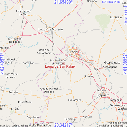
Loma de San Rafael GPS coordinates[2]
21° 0' 0.072" North, 101° 47' 33.504" West
| Map corner | latitude | longitude |
|---|---|---|
| Upper-left | 21.65499°, | -102.49577° |
| Center: | 21.00002°, | -101.79264° |
| Lower-right: | 20.34217°, | -101.08952° |
| Map W x H: | 146×146 km | = 90.7×90.7mi |
| max Lat: | 32.7° ⇑23.5% North |
| Loma de San Rafael: | 21.00002° |
| min Lat: | ⇓76.5% South 14.53588° |
| min Long | Loma de San Raf | max Long |
| -117.105° | -101.79264° | -86.73105° |
| W 20.3%⇐ | ⇒79.7% E |
Elevation
Elevation of Loma de San Rafael is 1764 m = 5787 ft, and this is 510.3 m = 1674 ft above average elevation for this country.
| Max E: |
3497 m = 11473 ft | 37.7% |
| Loma de San Rafael | 1764 m 5787 ft | |
| Avg. | 1253.7 m = 4113 ft | |
Min E: |
-1 m = -3 ft | 62.3% |
See also: Mexico elevation on elevation.city.
Geographical zone
Loma de San Rafael is located in North Torrid zone (between Equator and Tropic of Cancer). Distance of this Northern Tropic circle is 270.9 km =168.3 mi to North.| Distance of | km | miles | from Loma de San Rafael |
|---|---|---|---|
| North Pole | 7672.1 | 4767.2 | to North |
| Arctic Circle | 5066.2 | 3148 | to North |
| Tropic Cancer | 270.9 | 168.3 | to North |
| Equator | 2335 | 1450.9 | to South |


Nearby cities:
15 places around Loma de San Rafael: (largest is in red/bold)
• Arroyo Seco
2.3 km =1.4 mi,  265°
265°
• Barrio de Guadalupe del Mezquitillo
6.3 km =3.9 mi,  187°
187°
• Buenavista
5.2 km =3.2 mi,  359°
359°
• El Maguey
6 km =3.7 mi,  248°
248°
• El Mezquitillo
4.5 km =2.8 mi,  201°
201°
• El Ramillete
5.2 km =3.2 mi,  30°
30°
• Estación de San Francisco
5.3 km =3.3 mi,  321°
321°
• Fraccionamiento Villa Jardín
6.2 km =3.9 mi,  261°
261°
• Fraccionamiento la Mezquitera
4.5 km =2.8 mi,  283°
283°
• Malagana (San Antonio del Monte)
6.6 km =4.1 mi,  38°
38°
• Rincones de la Pradera
6.1 km =3.8 mi,  340°
340°
• San Francisco del Rincón
6.8 km =4.2 mi,  287°
287°
• San José de la Calera
4.1 km =2.5 mi,  132°
132°
• San Roque de Montes
2.2 km =1.4 mi,  300°
300°
• San Roque de Torres
7 km =4.3 mi,  243°
243°
Sources, notices
• [Note1] Compared only with cities in Mexico existing in our database
• [Src1] Map data: © OpenStreetMap contributors (CC-BY-SA)
• [Src2] Other city data from geonames.org with taken over terms of usage.
• [Src3] Geographical zone / Annual Mean Temperature by Robert A. Rohde @ Wikipedia
