Donaciano Ojeda geodata
Donaciano Ojeda (Michoacán) is a populated place; located in Mexico in America/Mexico_City (GMT-6) time zone. With population of 1,180 people, there are 7362 cities with bigger population in this country. Compared to other cities in Mexico, 54.2% of cities are located further ↑North; 67.2% of cities are located further →East and 84.7% of cities have lower elevation than Donaciano Ojeda. Note1


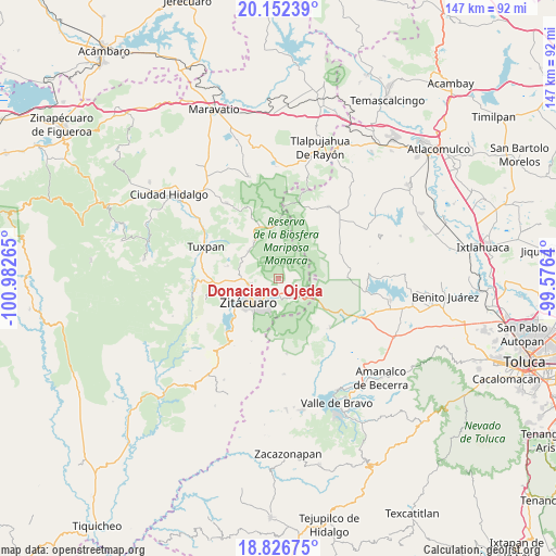
Donaciano Ojeda GPS coordinates[2]
19° 29' 27.348" North, 100° 16' 46.272" West
| Map corner | latitude | longitude |
|---|---|---|
| Upper-left | 20.15239°, | -100.98265° |
| Center: | 19.49093°, | -100.27952° |
| Lower-right: | 18.82675°, | -99.5764° |
| Map W x H: | 147.4×147.4 km | = 91.6×91.6mi |
| max Lat: | 32.7° ⇑54.2% North |
| Donaciano Ojeda: | 19.49093° |
| min Lat: | ⇓45.8% South 14.53588° |
| min Long | Donaciano Ojeda | max Long |
| -117.105° | -100.27952° | -86.73105° |
| W 32.8%⇐ | ⇒67.2% E |
Elevation
Elevation of Donaciano Ojeda is 2255 m = 7398 ft, and this is 1001.3 m = 3285 ft above average elevation for this country.
| Max E: |
3497 m = 11473 ft | 15.3% |
| Donaciano Ojeda | 2255 m 7398 ft | |
| Avg. | 1253.7 m = 4113 ft | |
Min E: |
-1 m = -3 ft | 84.7% |
See also: Mexico elevation on elevation.city.
Geographical zone
Donaciano Ojeda is located in North Torrid zone (between Equator and Tropic of Cancer). Distance of this Northern Tropic circle is 438.7 km =272.6 mi to North.| Distance of | km | miles | from Donaciano Ojeda |
|---|---|---|---|
| North Pole | 7839.9 | 4871.5 | to North |
| Arctic Circle | 5234 | 3252.3 | to North |
| Tropic Cancer | 438.7 | 272.6 | to North |
| Equator | 2167.2 | 1346.6 | to South |


Nearby cities:
15 places around Donaciano Ojeda: (largest is in red/bold)
• Carpinteros
3.9 km =2.4 mi,  268°
268°
• Chimusdá (Cuarta Manzana de Donaciano Ojeda)
2.8 km =1.7 mi,  226°
226°
• Colonia Emiliano Zapata (San Juan Zitácuaro)
5.5 km =3.4 mi,  209°
209°
• Crescencio Morales (San Mateo)
3.8 km =2.4 mi,  89°
89°
• Curungueo
7.3 km =4.5 mi,  246°
246°
• El Tigre (Segunda Manzana de Crescencio Morales)
4.2 km =2.6 mi,  117°
117°
• Francisco Serrato (San Bartolo)
2.7 km =1.7 mi,  49°
49°
• La Barranca (Quinta Manzana Crescencio Morales)
4 km =2.5 mi,  156°
156°
• La Fundición (Quinta Manzana)
4.7 km =2.9 mi, 212°
• La Joya de Manzanillo (Segunda Manzana)
6 km =3.7 mi,  203°
203°
• La Mesa (La Mesa de Cedano)
6.9 km =4.3 mi, 226°
• Macho de Agua
6.8 km =4.2 mi,  143°
143°
• Manzana de San Luis
7.9 km =4.9 mi,  1°
1°
• Rincón de Curungueo
6.8 km =4.2 mi,  262°
262°
• Toma de Agua
6.8 km =4.2 mi,  189°
189°
Sources, notices
• [Note1] Compared only with cities in Mexico existing in our database
• [Src1] Map data: © OpenStreetMap contributors (CC-BY-SA)
• [Src2] Other city data from geonames.org with taken over terms of usage.
• [Src3] Geographical zone / Annual Mean Temperature by Robert A. Rohde @ Wikipedia
