Progreso geodata
Progreso (Morelos) is a populated place; located in Mexico in America/Mexico_City (GMT-6) time zone. With population of 14,525 people, there are 668 cities with bigger population in this country. Compared to other cities in Mexico, 67.5% of cities are located further ↑North; 51.9% of cities are located further →East and 51.4% of cities have higher elevation than Progreso. Note1


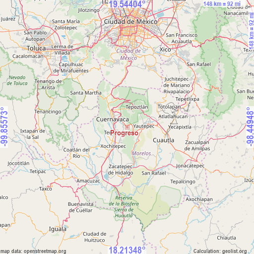
Progreso GPS coordinates[2]
18° 52' 48.288" North, 99° 9' 9.36" West
| Map corner | latitude | longitude |
|---|---|---|
| Upper-left | 19.54404°, | -99.85573° |
| Center: | 18.88008°, | -99.1526° |
| Lower-right: | 18.21348°, | -98.44948° |
| Map W x H: | 147.9×147.9 km | = 91.9×91.9mi |
| max Lat: | 32.7° ⇑67.5% North |
| Progreso: | 18.88008° |
| min Lat: | ⇓32.5% South 14.53588° |
| min Long | Progreso | max Long |
| -117.105° | -99.1526° | -86.73105° |
| W 48.1%⇐ | ⇒51.9% E |
Elevation
Elevation of Progreso is 1363 m = 4472 ft, and this is 109.3 m = 359 ft above average elevation for this country.
| Max E: |
3497 m = 11473 ft | 51.4% |
| Progreso | 1363 m 4472 ft | |
| Avg. | 1253.7 m = 4113 ft | |
Min E: |
-1 m = -3 ft | 48.6% |
See also: Mexico elevation on elevation.city.
Geographical zone
Progreso is located in North Torrid zone (between Equator and Tropic of Cancer). Distance of this Northern Tropic circle is 506.7 km =314.8 mi to North.| Distance of | km | miles | from Progreso |
|---|---|---|---|
| North Pole | 7907.8 | 4913.7 | to North |
| Arctic Circle | 5301.9 | 3294.4 | to North |
| Tropic Cancer | 506.7 | 314.8 | to North |
| Equator | 2099.3 | 1304.4 | to South |


Nearby cities:
15 places around Progreso: (largest is in red/bold)
• Ampliación las Fuentes
1.1 km =0.7 mi,  240°
240°
• Calera Chica
3.9 km =2.4 mi,  231°
231°
• Cliserio Alanís (San Gaspar)
2.2 km =1.4 mi,  200°
200°
• Colonia Josefa Ortiz de Domínguez
2.9 km =1.8 mi,  5°
5°
• Colonia Loma Esmeralda
3.7 km =2.3 mi,  0°
0°
• Colonia el Naranjo
1.9 km =1.2 mi,  210°
210°
• Ejido de Cazahuatal
0.4 km =0.2 mi,  307°
307°
• Emiliano Zapata
5.5 km =3.4 mi,  217°
217°
• Independencia
3.2 km =2 mi,  95°
95°
• Jiutepec
2.7 km =1.7 mi,  273°
273°
• La Joya
3.3 km =2.1 mi,  69°
69°
• Lomas del Pedregal
3.8 km =2.4 mi, 1°
• Tetecolala
4.8 km =3 mi,  347°
347°
• Tres de Mayo
6 km =3.7 mi,  257°
257°
• Unidad Habitacional Rinconada Acolapa
2.9 km =1.8 mi,  49°
49°
Sources, notices
• [Note1] Compared only with cities in Mexico existing in our database
• [Src1] Map data: © OpenStreetMap contributors (CC-BY-SA)
• [Src2] Other city data from geonames.org with taken over terms of usage.
• [Src3] Geographical zone / Annual Mean Temperature by Robert A. Rohde @ Wikipedia
