Los Olivos geodata
Los Olivos (Jalisco) is a populated place; located in Mexico in America/Mexico_City (GMT-6) time zone. With population of 7,647 people, there are 1215 cities with bigger population in this country. Compared to other cities in Mexico, 66.5% of cities are located further ↓South; 86.8% of cities are located further →East and 53.4% of cities have lower elevation than Los Olivos. Note1


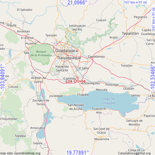
Los Olivos GPS coordinates[2]
20° 26' 21.012" North, 103° 14' 16.008" West
| Map corner | latitude | longitude |
|---|---|---|
| Upper-left | 21.0966°, | -103.94091° |
| Center: | 20.43917°, | -103.23778° |
| Lower-right: | 19.77891°, | -102.53466° |
| Map W x H: | 146.5×146.5 km | = 91×91mi |
| max Lat: | 32.7° ⇑33.5% North |
| Los Olivos: | 20.43917° |
| min Lat: | ⇓66.5% South 14.53588° |
| min Long | Los Olivos | max Long |
| -117.105° | -103.23778° | -86.73105° |
| W 13.2%⇐ | ⇒86.8% E |
Elevation
Elevation of Los Olivos is 1549 m = 5082 ft, and this is 295.3 m = 969 ft above average elevation for this country.
| Max E: |
3497 m = 11473 ft | 46.6% |
| Los Olivos | 1549 m 5082 ft | |
| Avg. | 1253.7 m = 4113 ft | |
Min E: |
-1 m = -3 ft | 53.4% |
See also: Mexico elevation on elevation.city.
Geographical zone
Los Olivos is located in North Torrid zone (between Equator and Tropic of Cancer). Distance of this Northern Tropic circle is 333.3 km =207.1 mi to North.| Distance of | km | miles | from Los Olivos |
|---|---|---|---|
| North Pole | 7734.4 | 4805.9 | to North |
| Arctic Circle | 5128.6 | 3186.8 | to North |
| Tropic Cancer | 333.3 | 207.1 | to North |
| Equator | 2272.6 | 1412.1 | to South |


Nearby cities:
15 places around Los Olivos: (largest is in red/bold)
• Buenavista
6.6 km =4.1 mi,  159°
159°
• Cajititlán
7.5 km =4.7 mi,  263°
263°
• Capulín
5.4 km =3.4 mi,  322°
322°
• El Muey
7.3 km =4.5 mi,  14°
14°
• El Rodeo
6.9 km =4.3 mi,  118°
118°
• Galaxia Bonito Jalisco
8.1 km =5 mi,  25°
25°
• La Alameda
6.3 km =3.9 mi,  350°
350°
• La Calera
2.1 km =1.3 mi,  310°
310°
• Los Cedros
5.5 km =3.4 mi,  174°
174°
• Los Freseros (Los Sabinos)
6 km =3.7 mi,  107°
107°
• Puerta del Sol [Fraccionamiento]
0.9 km =0.6 mi,  176°
176°
• Rancho Alegre [Fraccionamiento]
4.4 km =2.7 mi,  331°
331°
• Rinconada la Loma [Fraccionamiento]
2.6 km =1.6 mi,  49°
49°
• Santa Rosa
2.8 km =1.7 mi, 174°
• Valle de los Girasoles [Fraccionamiento]
4.3 km =2.7 mi, 108°
Sources, notices
• [Note1] Compared only with cities in Mexico existing in our database
• [Src1] Map data: © OpenStreetMap contributors (CC-BY-SA)
• [Src2] Other city data from geonames.org with taken over terms of usage.
• [Src3] Geographical zone / Annual Mean Temperature by Robert A. Rohde @ Wikipedia
