Los Torrentes geodata
Los Torrentes (Veracruz) is a populated place; located in Mexico in America/Mexico_City (GMT-6) time zone. With population of 4,665 people, there are 1975 cities with bigger population in this country. Compared to other cities in Mexico, 61.2% of cities are located further ↑North; 81.3% of cities are located further ←West and 83.6% of cities have higher elevation than Los Torrentes. Note1


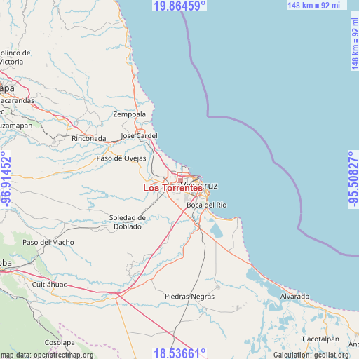
Los Torrentes GPS coordinates[2]
19° 12' 6.984" North, 96° 12' 41.004" West
| Map corner | latitude | longitude |
|---|---|---|
| Upper-left | 19.86459°, | -96.91452° |
| Center: | 19.20194°, | -96.21139° |
| Lower-right: | 18.53661°, | -95.50827° |
| Map W x H: | 147.7×147.7 km | = 91.8×91.8mi |
| max Lat: | 32.7° ⇑61.2% North |
| Los Torrentes: | 19.20194° |
| min Lat: | ⇓38.8% South 14.53588° |
| min Long | Los Torrentes | max Long |
| -117.105° | -96.21139° | -86.73105° |
| W 81.3%⇐ | ⇒18.7% E |
Elevation
Elevation of Los Torrentes is 54 m = 177 ft, and this is 1199.7 m = 3936 ft below average elevation for this country.
| Max E: |
3497 m = 11473 ft | 83.6% |
| Avg. | 1253.7 m = 4113 ft | |
| Los Torrentes | 54 m = 177 ft | |
Min E: |
-1 m = -3 ft | 16.4% |
See also: Mexico elevation on elevation.city.
Geographical zone
Los Torrentes is located in North Torrid zone (between Equator and Tropic of Cancer). Distance of this Northern Tropic circle is 470.9 km =292.6 mi to North.| Distance of | km | miles | from Los Torrentes |
|---|---|---|---|
| North Pole | 7872 | 4891.4 | to North |
| Arctic Circle | 5266.1 | 3272.2 | to North |
| Tropic Cancer | 470.9 | 292.6 | to North |
| Equator | 2135.1 | 1326.7 | to South |


Nearby cities:
15 places around Los Torrentes: (largest is in red/bold)
• Arboledas
0.7 km =0.4 mi,  331°
331°
• Colonia Chalchihuecan
1.4 km =0.9 mi,  346°
346°
• Colonia el Renacimiento
2 km =1.2 mi,  344°
344°
• Condado del Valle Dorado (Segunda Sección)
2.1 km =1.3 mi,  359°
359°
• Delfino Victoria (Santa Fe)
6.5 km =4 mi,  275°
275°
• Fraccionamiento Costa Dorada
0.9 km =0.6 mi,  323°
323°
• Fraccionamiento Geovillas los Pinos
2.3 km =1.4 mi, 317°
• Fraccionamiento Xana
5.6 km =3.5 mi,  144°
144°
• Infonavit Orquideas
1.1 km =0.7 mi, 342°
• Las Amapolas
5.7 km =3.5 mi,  165°
165°
• Lomas de Río Medio Cuatro
1 km =0.6 mi, 174°
• Oasis
0.8 km =0.5 mi,  267°
267°
• Río Medio [Granja]
0.9 km =0.6 mi,  16°
16°
• Santa Rita
6.4 km =4 mi,  233°
233°
• Valente Diaz
4.3 km =2.7 mi,  187°
187°
Sources, notices
• [Note1] Compared only with cities in Mexico existing in our database
• [Src1] Map data: © OpenStreetMap contributors (CC-BY-SA)
• [Src2] Other city data from geonames.org with taken over terms of usage.
• [Src3] Geographical zone / Annual Mean Temperature by Robert A. Rohde @ Wikipedia
