Cozotlán Norte geodata
Cozotlán Norte (State of Mexico) is a populated place; located in Mexico in America/Mexico_City (GMT-6) time zone. With population of 1,505 people, there are 5734 cities with bigger population in this country. Compared to other cities in Mexico, 50.7% of cities are located further ↓South; 52.6% of cities are located further ←West and 88.2% of cities have lower elevation than Cozotlán Norte. Note1


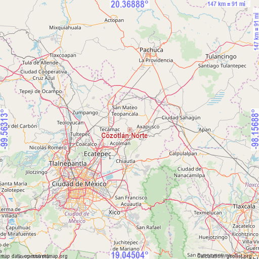
Cozotlán Norte GPS coordinates[2]
19° 42' 29.988" North, 98° 51' 36" West
| Map corner | latitude | longitude |
|---|---|---|
| Upper-left | 20.36888°, | -99.56313° |
| Center: | 19.70833°, | -98.86° |
| Lower-right: | 19.04504°, | -98.15688° |
| Map W x H: | 147.2×147.2 km | = 91.5×91.5mi |
| max Lat: | 32.7° ⇑49.3% North |
| Cozotlán Norte: | 19.70833° |
| min Lat: | ⇓50.7% South 14.53588° |
| min Long | Cozotlán Norte | max Long |
| -117.105° | -98.86° | -86.73105° |
| W 52.6%⇐ | ⇒47.4% E |
Elevation
Elevation of Cozotlán Norte is 2349 m = 7707 ft, and this is 1095.3 m = 3594 ft above average elevation for this country.
| Max E: |
3497 m = 11473 ft | 11.8% |
| Cozotlán Norte | 2349 m 7707 ft | |
| Avg. | 1253.7 m = 4113 ft | |
Min E: |
-1 m = -3 ft | 88.2% |
See also: Mexico elevation on elevation.city.
Geographical zone
Cozotlán Norte is located in North Torrid zone (between Equator and Tropic of Cancer). Distance of this Northern Tropic circle is 414.6 km =257.6 mi to North.| Distance of | km | miles | from Cozotlán Norte |
|---|---|---|---|
| North Pole | 7815.7 | 4856.4 | to North |
| Arctic Circle | 5209.8 | 3237.2 | to North |
| Tropic Cancer | 414.6 | 257.6 | to North |
| Equator | 2191.4 | 1361.7 | to South |


Nearby cities:
15 places around Cozotlán Norte: (largest is in red/bold)
• Ejido Atlatongo
5.9 km =3.7 mi,  228°
228°
• Ejido San Martín
3 km =1.9 mi,  80°
80°
• Ejido de San Sebastián
4.8 km =3 mi,  155°
155°
• El Potrero (Ejido Purificación)
3.9 km =2.4 mi,  200°
200°
• Ixtlahuaca
3.8 km =2.4 mi,  332°
332°
• San Agustín Actipac
4.7 km =2.9 mi,  303°
303°
• San Antonio de las Palmas
1.1 km =0.7 mi,  17°
17°
• San Francisco Mazapa
3.3 km =2.1 mi,  125°
125°
• San Isidro del Progreso
5.8 km =3.6 mi,  271°
271°
• San Lorenzo Tlalmimilolpan
4.7 km =2.9 mi, 195°
• San Martín de las Pirámides
2.6 km =1.6 mi,  96°
96°
• San Sebastián Xolalpa
3.9 km =2.4 mi, 156°
• Santa María Palapa
3.3 km =2.1 mi, 21°
• Teotihuacán
2.2 km =1.4 mi,  183°
183°
• Teotihuacán de Arista
2.1 km =1.3 mi, 182°
Sources, notices
• [Note1] Compared only with cities in Mexico existing in our database
• [Src1] Map data: © OpenStreetMap contributors (CC-BY-SA)
• [Src2] Other city data from geonames.org with taken over terms of usage.
• [Src3] Geographical zone / Annual Mean Temperature by Robert A. Rohde @ Wikipedia
