Almoloya geodata
Almoloya (Hidalgo) is a populated place; located in Mexico in America/Mexico_City (GMT-6) time zone. With population of 1,287 people, there are 6738 cities with bigger population in this country. Compared to other cities in Mexico, 60.3% of cities are located further ↓South; 57.9% of cities are located further ←West and 81.9% of cities have lower elevation than Almoloya. Note1


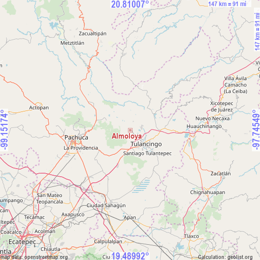
Almoloya GPS coordinates[2]
20° 9' 5.004" North, 98° 26' 54.996" West
| Map corner | latitude | longitude |
|---|---|---|
| Upper-left | 20.81007°, | -99.15174° |
| Center: | 20.15139°, | -98.44861° |
| Lower-right: | 19.48992°, | -97.74549° |
| Map W x H: | 146.8×146.8 km | = 91.2×91.2mi |
| max Lat: | 32.7° ⇑39.7% North |
| Almoloya: | 20.15139° |
| min Lat: | ⇓60.3% South 14.53588° |
| min Long | Almoloya | max Long |
| -117.105° | -98.44861° | -86.73105° |
| W 57.9%⇐ | ⇒42.1% E |
Elevation
Elevation of Almoloya is 2186 m = 7172 ft, and this is 932.3 m = 3059 ft above average elevation for this country.
| Max E: |
3497 m = 11473 ft | 18.1% |
| Almoloya | 2186 m 7172 ft | |
| Avg. | 1253.7 m = 4113 ft | |
Min E: |
-1 m = -3 ft | 81.9% |
See also: Mexico elevation on elevation.city.
Geographical zone
Almoloya is located in North Torrid zone (between Equator and Tropic of Cancer). Distance of this Northern Tropic circle is 365.3 km =227 mi to North.| Distance of | km | miles | from Almoloya |
|---|---|---|---|
| North Pole | 7766.4 | 4825.8 | to North |
| Arctic Circle | 5160.5 | 3206.6 | to North |
| Tropic Cancer | 365.3 | 227 | to North |
| Equator | 2240.6 | 1392.2 | to South |


Nearby cities:
15 places around Almoloya: (largest is in red/bold)
• Acatlán
1.1 km =0.7 mi,  124°
124°
• Colonia 28 de Mayo (Santa Rosa)
6.3 km =3.9 mi,  75°
75°
• Colonia Agustín Olvera
3.5 km =2.2 mi,  155°
155°
• Colonia Benito Juárez
1.4 km =0.9 mi,  178°
178°
• Colonia Chauténco
2.4 km =1.5 mi, 180°
• Encinillos
5.4 km =3.4 mi,  17°
17°
• Fraccionamiento Carlos Salinas de Gortari
5 km =3.1 mi, 157°
• Jaltepec
5.2 km =3.2 mi,  140°
140°
• Los Arcos
2.8 km =1.7 mi,  2°
2°
• Metepec Primero
2 km =1.2 mi, 122°
• Mixquiapan
3.7 km =2.3 mi,  254°
254°
• Rincones de la Hacienda
6 km =3.7 mi,  125°
125°
• Santa María el Chico
7.4 km =4.6 mi, 132°
• Santo Domingo Agua Zarca
5.3 km =3.3 mi,  271°
271°
• Vicente Guerrero
8.1 km =5 mi,  43°
43°
Sources, notices
• [Note1] Compared only with cities in Mexico existing in our database
• [Src1] Map data: © OpenStreetMap contributors (CC-BY-SA)
• [Src2] Other city data from geonames.org with taken over terms of usage.
• [Src3] Geographical zone / Annual Mean Temperature by Robert A. Rohde @ Wikipedia
