Los Sauces geodata
Los Sauces (Michoacán) is a populated place; located in Mexico in America/Mexico_City (GMT-6) time zone. With population of 858 people, there are 10191 cities with bigger population in this country. Compared to other cities in Mexico, 51.6% of cities are located further ↓South; 68.2% of cities are located further →East and 82.9% of cities have lower elevation than Los Sauces. Note1


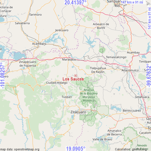
Los Sauces GPS coordinates[2]
19° 45' 12.996" North, 100° 22' 45.984" West
| Map corner | latitude | longitude |
|---|---|---|
| Upper-left | 20.41397°, | -101.08257° |
| Center: | 19.75361°, | -100.37944° |
| Lower-right: | 19.0905°, | -99.67632° |
| Map W x H: | 147.2×147.2 km | = 91.5×91.5mi |
| max Lat: | 32.7° ⇑48.4% North |
| Los Sauces: | 19.75361° |
| min Lat: | ⇓51.6% South 14.53588° |
| min Long | Los Sauces | max Long |
| -117.105° | -100.37944° | -86.73105° |
| W 31.8%⇐ | ⇒68.2% E |
Elevation
Elevation of Los Sauces is 2212 m = 7257 ft, and this is 958.3 m = 3144 ft above average elevation for this country.
| Max E: |
3497 m = 11473 ft | 17.1% |
| Los Sauces | 2212 m 7257 ft | |
| Avg. | 1253.7 m = 4113 ft | |
Min E: |
-1 m = -3 ft | 82.9% |
See also: Mexico elevation on elevation.city.
Geographical zone
Los Sauces is located in North Torrid zone (between Equator and Tropic of Cancer). Distance of this Northern Tropic circle is 409.5 km =254.5 mi to North.| Distance of | km | miles | from Los Sauces |
|---|---|---|---|
| North Pole | 7810.7 | 4853.3 | to North |
| Arctic Circle | 5204.8 | 3234.1 | to North |
| Tropic Cancer | 409.5 | 254.5 | to North |
| Equator | 2196.4 | 1364.8 | to South |


Nearby cities:
15 places around Los Sauces: (largest is in red/bold)
• Aporo
9.8 km =6.1 mi,  199°
199°
• Cachivi
6.3 km =3.9 mi,  21°
21°
• Campo Hermoso
10.3 km =6.4 mi,  344°
344°
• Chincua (Colonia Emiliano Zapata)
9.4 km =5.8 mi,  85°
85°
• El Calabozo Segunda Fracción
3.6 km =2.2 mi,  66°
66°
• El Huérfano (Emiliano Zapata)
8.2 km =5.1 mi, 73°
• José María Morelos
4.3 km =2.7 mi, 16°
• Milpillas
7.7 km =4.8 mi,  54°
54°
• San Antonio Primera Fracción
2.5 km =1.6 mi,  108°
108°
• San Francisco Epunguio
8.6 km =5.3 mi,  226°
226°
• San José Soto
5.6 km =3.5 mi,  56°
56°
• San Juan Huerta
5.3 km =3.3 mi,  326°
326°
• Segunda Manzana de Chincua
9.2 km =5.7 mi, 70°
• Senguio
3.4 km =2.1 mi,  128°
128°
• Tupátaro
10.2 km =6.3 mi, 49°
Sources, notices
• [Note1] Compared only with cities in Mexico existing in our database
• [Src1] Map data: © OpenStreetMap contributors (CC-BY-SA)
• [Src2] Other city data from geonames.org with taken over terms of usage.
• [Src3] Geographical zone / Annual Mean Temperature by Robert A. Rohde @ Wikipedia
