El Lindero geodata
El Lindero (Veracruz) is a populated place; located in Mexico in America/Mexico_City (GMT-6) time zone. With population of 632 people, there are 13699 cities with bigger population in this country. Compared to other cities in Mexico, 65.5% of cities are located further ↑North; 72.8% of cities are located further ←West and 88% of cities have lower elevation than El Lindero. Note1


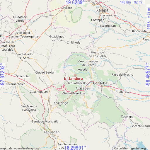
El Lindero GPS coordinates[2]
18° 57' 55.008" North, 97° 10' 8.004" West
| Map corner | latitude | longitude |
|---|---|---|
| Upper-left | 19.6289°, | -97.87202° |
| Center: | 18.96528°, | -97.16889° |
| Lower-right: | 18.29901°, | -96.46577° |
| Map W x H: | 147.9×147.9 km | = 91.9×91.9mi |
| max Lat: | 32.7° ⇑65.5% North |
| El Lindero: | 18.96528° |
| min Lat: | ⇓34.5% South 14.53588° |
| min Long | El Lindero | max Long |
| -117.105° | -97.16889° | -86.73105° |
| W 72.8%⇐ | ⇒27.2% E |
Elevation
Elevation of El Lindero is 2342 m = 7684 ft, and this is 1088.3 m = 3571 ft above average elevation for this country.
| Max E: |
3497 m = 11473 ft | 12% |
| El Lindero | 2342 m 7684 ft | |
| Avg. | 1253.7 m = 4113 ft | |
Min E: |
-1 m = -3 ft | 88% |
See also: Mexico elevation on elevation.city.
Geographical zone
El Lindero is located in North Torrid zone (between Equator and Tropic of Cancer). Distance of this Northern Tropic circle is 497.2 km =308.9 mi to North.| Distance of | km | miles | from El Lindero |
|---|---|---|---|
| North Pole | 7898.3 | 4907.8 | to North |
| Arctic Circle | 5292.4 | 3288.5 | to North |
| Tropic Cancer | 497.2 | 308.9 | to North |
| Equator | 2108.7 | 1310.3 | to South |


Nearby cities:
15 places around El Lindero: (largest is in red/bold)
• Agua Escondida
3.8 km =2.4 mi,  288°
288°
• Chilapa
3 km =1.9 mi,  30°
30°
• Cruz de Chocamán
1.1 km =0.7 mi,  324°
324°
• Cumbre del Español
2.3 km =1.4 mi,  71°
71°
• El Paso
2.7 km =1.7 mi,  304°
304°
• El Zapote
2.8 km =1.7 mi,  105°
105°
• La Lagunilla
3.8 km =2.4 mi,  17°
17°
• Los Fresnos
3.6 km =2.2 mi,  126°
126°
• Metlac Hernández (Metlac Primero)
3 km =1.9 mi,  63°
63°
• Papalotla
2 km =1.2 mi,  284°
284°
• Texmalaca
1.9 km =1.2 mi,  224°
224°
• Tuzantla
1.6 km =1 mi,  124°
124°
• Villa Hermosa
1.2 km =0.7 mi, 56°
• Xiquila
3 km =1.9 mi,  246°
246°
• Xometla
2.2 km =1.4 mi, 298°
Sources, notices
• [Note1] Compared only with cities in Mexico existing in our database
• [Src1] Map data: © OpenStreetMap contributors (CC-BY-SA)
• [Src2] Other city data from geonames.org with taken over terms of usage.
• [Src3] Geographical zone / Annual Mean Temperature by Robert A. Rohde @ Wikipedia
