Veinte de Abril geodata
Veinte de Abril (Chiapas) is a populated place; located in Mexico in America/Mexico_City (GMT-6) time zone. With population of 572 people, there are 14957 cities with bigger population in this country. Compared to other cities in Mexico, 97.6% of cities are located further ↑North; 95.4% of cities are located further ←West and 66.8% of cities have higher elevation than Veinte de Abril. Note1


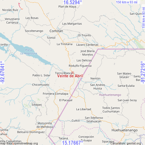
Veinte de Abril GPS coordinates[2]
15° 51' 15.012" North, 91° 58' 31.008" West
| Map corner | latitude | longitude |
|---|---|---|
| Upper-left | 16.5294°, | -92.67841° |
| Center: | 15.85417°, | -91.97528° |
| Lower-right: | 15.17667°, | -91.27216° |
| Map W x H: | 150.4×150.4 km | = 93.5×93.5mi |
| max Lat: | 32.7° ⇑97.6% North |
| Veinte de Abril: | 15.85417° |
| min Lat: | ⇓2.4% South 14.53588° |
| min Long | Veinte de Abril | max Long |
| -117.105° | -91.97528° | -86.73105° |
| W 95.4%⇐ | ⇒4.6% E |
Elevation
Elevation of Veinte de Abril is 597 m = 1959 ft, and this is 656.7 m = 2155 ft below average elevation for this country.
| Max E: |
3497 m = 11473 ft | 66.8% |
| Avg. | 1253.7 m = 4113 ft | |
| Veinte de Abril | 597 m = 1959 ft | |
Min E: |
-1 m = -3 ft | 33.2% |
See also: Mexico elevation on elevation.city.
Geographical zone
Veinte de Abril is located in North Torrid zone (between Equator and Tropic of Cancer). Distance of this Northern Tropic circle is 843.1 km =523.9 mi to North.| Distance of | km | miles | from Veinte de Abril |
|---|---|---|---|
| North Pole | 8244.2 | 5122.7 | to North |
| Arctic Circle | 5638.4 | 3503.5 | to North |
| Tropic Cancer | 843.1 | 523.9 | to North |
| Equator | 1762.8 | 1095.4 | to South |


Nearby cities:
15 places around Veinte de Abril: (largest is in red/bold)
• Doctor Rodulfo Figueroa (Tierra Blanca)
9.3 km =5.8 mi,  267°
267°
• Flor de Mayo
3.5 km =2.2 mi, 267°
• Joaquín Miguel Gutiérrez
5.3 km =3.3 mi,  147°
147°
• Juan Sabines Gutiérrez
0.9 km =0.6 mi,  255°
255°
• La Gloria
12.2 km =7.6 mi,  5°
5°
• Nueva Libertad (El Colorado)
10.2 km =6.3 mi,  298°
298°
• Nuevo Llano Grande
6.8 km =4.2 mi,  121°
121°
• Nuevo San Gregorio
1.4 km =0.9 mi,  221°
221°
• Nuevo Villaflores
0.3 km =0.2 mi, 300°
• Rodulfo Figueroa
10.6 km =6.6 mi,  46°
46°
• Río Grande el Grijalva
3.8 km =2.4 mi, 262°
• Sabinalito
17 km =10.6 mi,  184°
184°
• San Caralampio
7 km =4.3 mi,  246°
246°
• San Francisco de Asís
17 km =10.6 mi,  344°
344°
• Sinaloa
17 km =10.6 mi,  284°
284°
Sources, notices
• [Note1] Compared only with cities in Mexico existing in our database
• [Src1] Map data: © OpenStreetMap contributors (CC-BY-SA)
• [Src2] Other city data from geonames.org with taken over terms of usage.
• [Src3] Geographical zone / Annual Mean Temperature by Robert A. Rohde @ Wikipedia
